
Page 50 - Demo Faces
P. 50
50
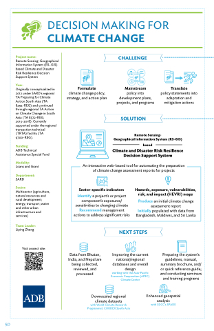
DECISION MAKING FOR
CLIMATE CHANGE
Project name:
Remote Sensing-Geographical Information System (RS-GIS) based Climate and Disaster Risk Resilience Decision Support System
Year:
Originally conceptualized in 2012 under SARD’s regional TA Preparing for Climate Action South Asia (TA 8292-REG) and continued through regional TA Action on Climate Change in South Asia (TA 8572-REG, 2013-2018). Currently supported under the regional transaction technical (TRTA) facility (TA 9700-REG).
Funding:
ADB Technical Assistance Special Fund
Modality:
Loans and Grant
Department:
SARD
Sector:
Multisector (agriculture, natural resources and rural development; energy; transport; water and other urban infrastructure and services)
Team Leader:
Liping Zheng
Visit project site:
Formulate
climate change policy, strategy, and action plan
CHALLENGE:
Mainstream
policy into development plans, projects, and programs
SOLUTION
Translate
policy statements into adaptation and mitigation actions
Remote Sensing- Geographical Information System (RS-GIS)
based
Climate and Disaster Risk Resilience Decision Support System
An interactive web-based tool for automating the preparation
of climate change assessment reports for projects
Sector-specific indicators
Identify a project’s or project component’s exposures/ sensitivities to changing climate Recommend management actions to address significant risks
!
Hazards, exposure, vulnerabilities, risk, and impact (HEVRI) maps
Produce an initial climate change assessment report
Initially populated with data from Bangladesh, Maldives, and Sri Lanka
Data from Bhutan, India, and Nepal are being collected, reviewed, and processed
NEXT STEPS
Improving the current national/regional databases and overall
design
working with the Asia-Pacific Economic Cooperation (APEC) Climate Center
Preparing the system’s guidelines, manual, summary brochure, and/ or quick reference guide; and conducting seminars and training programs
Downscaled regional
climate datasets
with World Climate Research Programme’s CORDEX South Asia
Enhanced geospatial
analysis
with SDCC’s SPADE
