
Page 23 - The Driver's Guide to the Wild Atlantic
P. 23
The Driver's Guide
Clewbay
Ireland’s sixth National Park and in the village of Ballycroy.
It comprises over 15,000 hectares of Atlantic blanket bog and mountainous terrain, covering a vast uninhabited and unspoilt wilderness dominated by the Nephin Beg mountain range.
Between Nephin Beg and Slieve Carr, at 721 metres above sea level, the highest mountain in the range, lie the Scardaun Loughs. To the west of the mountains is the Owenduff bog.
This is one of the last intact active blanket bog systems in Ireland and Western Europe and is an important scientific and scenic feature of the National Park. The Park also protects a variety of other important habitats and species. These include alpine heath, upland grassland, heath and lakes and river catchments. Greenland White- fronted geese, Golden Plover, Red Grouse and Otters are just some of the important fauna found within the Park.
The Bangor Trail which runs through this beautifully remote area has been described as the loneliest trail in Ireland, and is an ancient route through the Nephin Begs. Your mobile phone will take pictures here but that’s all.
KILLARY FJORD
Killary Harbour is a fjord that forms a natural border between counties Galway and Mayo. On it’s northern shore towers Mweelrea, the highest point in Connacht.
The Mweelrea range encompasses five tops, aligned around a dramatic horseshoe, with two summits, Mweelrea (814 m) and Ben Bury (795 m). The easiest route to the summit starts near the Silver Strand, on the western side of the mountain. For amateur geologists there are more interesting routes capturing the glacial geology of the area.
This is some of the most dramatic scenery anywhere along the Wild Atlantic Way and well worth hike on a clear day to experience it. To the south of the fjord you can see the Maumturk Mountains and the Twelve Bens in the neighbouring Connemara region of West Galway.
The Green Road, a route that travels eastward along the side of the fjord toward Leenane is a road stretches almost 10km and was built in the 19th century as a famine relief project.
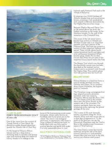
CLARE ISLAND
FERRY FROM ROONAGH QUAY 10 min ride
One of the views from the summit of Croagh Patrick is Clare Island, the distinctive saddle shaped island that guards the Atlantic side of Clew Bay.
It’s the largest of Mayo’s offshore islands and has a long history stretching back to neolithic and bronze ages and reaching deep into medieval history thanks to its linkage as the
Clare Island
home of the buccaneering pirate queen Granuaile, whose castle, known as Rockfleet, and burial place are on the island. The island is an ecological sanctuary, its spectacular cliffs home to large numbers of nesting sea birds, its fields filled with rare flora and its pristine beaches and gentle hills make it a truly memorable place to visit.
BALLYCROY NATIONAL PARK
Wild Nephin Ballycroy National Park was established in November 1998, it is
WILD ATLANTIC 23
