
Page 8 - Penn State Civil and Environmental Engineering Magazine
P. 8
FACULTY RESEARCH
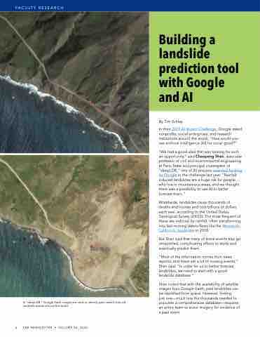
In “deepLDB,” Google Earth images are used to identify past rainfall-induced landslide events around the world.
By Tim Schley
In their 2019 AI Impact Challenge, Google asked nonprofits, social enterprises, and research institutions around the world, “How would you use artificial intelligence (AI) for social good?”
“We had a good idea that was looking for such an opportunity,” said Chaopeng Shen, associate professor of civil and environmental engineering at Penn State and principal investigator of “deepLDB,” one of 20 projects awarded funding by Google in the challenge last year. “Rainfall- induced landslides are a huge risk for people who live in mountainous areas, and we thought there was a possibility to use AI to better forecast them.”
Worldwide, landslides cause thousands of deaths and injuries and cost billions of dollars each year, according to the United States Geological Survey (USGS). The most frequent of these are induced by rainfall, often transforming into fast-moving debris flows like the Montecito, California, mudslides in 2018.
But Shen said that many of these events also go unreported, complicating efforts to study and eventually predict them.
“Most of the information comes from news reports, and there are a lot of missing events,” Shen said. “In order for us to better forecast landslides, we need to start with a good landslide database.”
Shen noted that with the availability of satellite images from Google Earth, past landslides can be identified from space. However, finding
just one—much less the thousands needed to populate a comprehensive database—requires an entire team to scour imagery for evidence of a past event.
8 CEE NEWSLETTER • VOLUME 36, 2020
Building a landslide prediction tool with Google and AI
