
Page 11 - Olivenhain Book
P. 11
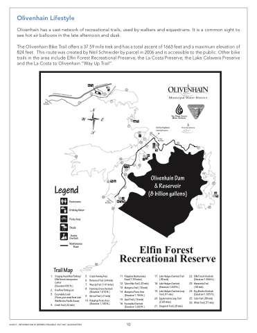
 Olivenhain Lifestyle
Olivenhain has a vast network of recreational trails, used by walkers and equestrians. It is a common sight to see hot air balloons in the late afternoon and dusk.
The Olivenhain Bike Trail offers a 37.59 mile trek and has a total ascent of 1663 feet and a maximum elevation of 824 feet. This route was created by Neil Schneider by parcel in 2006 and is accessible to the public. Other bike trails in the area include Elfin Forest Recreational Preserve, the La Costa Preserve, the Lake Calavera Preserve and the La Costa to Olivenhain “Way Up Trail”.
02/2017 - INFORMATION IS DEEMED RELIABLE, BUT NOT GUARANTEED.
10
1. Staging Area/Main Parking/ Elfin Forest Interpretive Center
(Elevation 492 ft.)
2. Overflow Parking Lot
3. Escondido Creek
(Flows year round from Lake Wohlford to Pacific Ocean)
4. Creek Trail (.22 mile)
5. Creek Viewing Area
6. Botanical Trail (.64 mile)
7. Way Up Trail (1.41 miles)
8. Harmony Grove Overlook (Elevation 1,010 ft.)
9. Me-xal Trail (.21 mile)
10. Ridgetop Picnic Area (Elevation 1,140 ft.)
11. Ridgeline Maintenance Road (1.39 miles)
12. Tykes Hike Trail (.23 mile)
13. Mariposa Trail (.18 mile)
14. Mariposa Picnic Area (Elevation 1,155 ft.)
15. Quail Trail (.16 mile)
16. Escondido Overlook (Elevation 1,200 ft.)
17. Lake Hodges Overlook Trail (.93 mile)
18. Lake Hodges Overlook (Elevation 1,200 ft.)
19. Lake Hodges Overlook Loop Trail (.81 mile)
20. Equine Incline Loop Trail (2.60 miles)
21. Chaparral Trail (.28 mile)
22. Elfin Forest Overlook (Elevation 1,346 ft.)
23. Manzanita Trail (.30 mile)
24. Ray Brooks Overlook (Elevation 1,185 ft.)
25. Cielo Trail (.88 mile) 26. Witch Trail (.37 mile)
Del Dios Highlands County Preserve
26
