
Page 102 - Green - Maritime Archaeology: A Technical Handbook. 2nd ed
P. 102
Chapter 3: Search and Survey 81
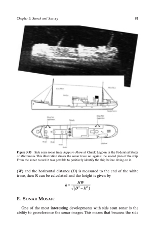
Figure 3.35 Side scan sonar trace Sapporo Maru at Chuuk Lagoon in the Federated States of Micronesia. This illustration shows the sonar trace set against the scaled plan of the ship. From the sonar record it was possible to positively identify the ship before diving on it.
(W) and the horizontal distance (D) is measured to the end of the white trace, then R can be calculated and the height is given by
E. SONAR MOSAIC
One of the most interesting developments with side scan sonar is the ability to georeference the sonar images. This means that because the side
h= HW (D2 -H2)
