
Page 163 - Green - Maritime Archaeology: A Technical Handbook. 2nd ed
P. 163
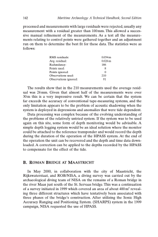
142 Maritime Archaeology: A Technical Handbook, Second Edition
processed and measurements with large residuals were rejected, usually any measurement with a residual greater than 100 mm. This allowed a succes- sive manual refinement of the measurements. As a test all the measure- ments relating to control points were gathered together and an adjustment run on them to determine the best fit for these data. The statistics were as follows:
RMS residuals:
Avg. residual: Redundancy:
Points used:
Points ignored: Observations used: Observations ignored:
0.034m 0.026 m 186
8
0 210 91
The results show that in the 210 measurements used the average resid- ual was 26mm. Given that almost half of the measurements were over 30m this is a very impressive result. We can be certain that the system far exceeds the accuracy of conventional tape-measuring systems, and the only limitation appears to be the problem of acoustic shadowing when the system is deployed in depressions and anomalies that were tide dependent.
Data processing was complex because of the evolving understanding of the problems of the relatively untried system. If the system was to be used again on this site, some form of depth monitoring would be advisable. A simple depth logging system would be an ideal solution where the monitor could be attached to the reference transponder and would record the depth during the duration of the operation of the HPASS system. At the end of the operation the unit can be recovered and the depth and time data down- loaded. A correction can be applied to the depths recorded by the HPASS to compensate for the effect of the tide.
B. ROMAN BRIDGE AT MAASTRICHT
In May 2000, in collaboration with the city of Maastricht, the Rijkswaterstaat, and ROB/NISA, a diving survey was carried out by the archaeological diving team of NISA on the remains of a Roman bridge in the river Maas just south of the St. Servaas bridge. This was a continuation of a survey initiated in 1999 which covered an area of about 400 m2 reveal- ing three different structures which have tentatively been associated with three phases of the bridge’s construction. After utilizing the Sonic High Accuracy Ranging and Positioning System. (SHARPS) system in the 1999 campaign, NISA requested the use of HPASS.
