
Page 175 - Green - Maritime Archaeology: A Technical Handbook. 2nd ed
P. 175
154 Maritime Archaeology: A Technical Handbook, Second Edition
their tripods around the tower and the diver unit was placed on the target points. The operation, including positioning the tripods, placing the trans- ponders in the tripods, erecting the photo tower, taking intertransponder distances, and taking measurements took 95 minutes of which 20 minutes was involved in the survey itself. Downloading and processing data took 20 minutes. The resulting adjustment resulted in AR = 0.016 m and RMS = 0.032 m.
A. RESULTS
These data were processed either with Site Surveyor or PhotoModeler software. It was decided to process these data so that each system had exactly the same coordinate system. In that way it would be possible to compare the accuracy of the systems.
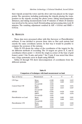
Table II–VII shows the values of the coordinates of the targets for the six different methods of recording. The 18 targets are given X, Y, and Z coordinates where point 1 = (0,0,0) the origin (a corner of the base of grid frame), point 3 the X-axis, and point 7 the Y-axis. It was noted that there was a large systematic error in depth using HPASS.
Tables II through VII show intercomparison of coordinates from the different systems.
Table II
Comparison of techniques with hand measurement on land.
Type od Survey UW Tape
Control Point UW HPASS
PhotoModeler on Land PhotoModeler UW
Measurement X Mean -0.008
Y Z
-0.006 0.025
0.009 0.015
0.010 0.031
0.015 0.047
-0.028 0.028 0.023 0.076
0.000 0.001 0.009 0.011
0.015 0.000 0.015 0.017
SDEV Overall SD Mean SDEV Overall SD Mean SDEV Overall SD Mean SDEV Overall SD Mean SDEV Overall SD
0.015 0.020 0.018 0.040 0.037
-0.004 0.027 0.053 0.006 0.019 0.014 0.014 0.019 0.018
