
Page 213 - Green - Maritime Archaeology: A Technical Handbook. 2nd ed
P. 213
192 Maritime Archaeology: A Technical Handbook, Second Edition
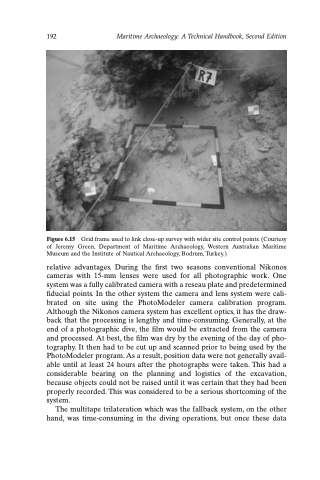
Figure 6.15 Grid frame used to link close-up survey with wider site control points. (Courtesy of Jeremy Green, Department of Maritime Archaeology, Western Australian Maritime Museum and the Institute of Nautical Archaeology, Bodrum, Turkey.)
relative advantages. During the first two seasons conventional Nikonos cameras with 15-mm lenses were used for all photographic work. One system was a fully calibrated camera with a reseau plate and predetermined fiducial points. In the other system the camera and lens system were cali- brated on site using the PhotoModeler camera calibration program. Although the Nikonos camera system has excellent optics, it has the draw- back that the processing is lengthy and time-consuming. Generally, at the end of a photographic dive, the film would be extracted from the camera and processed. At best, the film was dry by the evening of the day of pho- tography. It then had to be cut up and scanned prior to being used by the PhotoModeler program. As a result, position data were not generally avail- able until at least 24 hours after the photographs were taken. This had a considerable bearing on the planning and logistics of the excavation, because objects could not be raised until it was certain that they had been properly recorded. This was considered to be a serious shortcoming of the system.
The multitape trilateration which was the fallback system, on the other hand, was time-consuming in the diving operations, but once these data
