
Page 82 - Green - Maritime Archaeology: A Technical Handbook. 2nd ed
P. 82
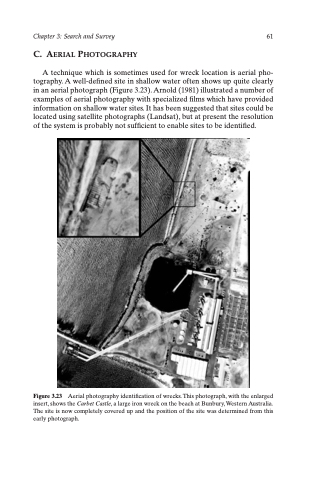
Chapter 3: Search and Survey 61 C. AERIAL PHOTOGRAPHY
A technique which is sometimes used for wreck location is aerial pho- tography. A well-defined site in shallow water often shows up quite clearly in an aerial photograph (Figure 3.23). Arnold (1981) illustrated a number of examples of aerial photography with specialized films which have provided information on shallow water sites. It has been suggested that sites could be located using satellite photographs (Landsat), but at present the resolution of the system is probably not sufficient to enable sites to be identified.
Figure 3.23 Aerial photography identification of wrecks. This photograph, with the enlarged insert, shows the Carbet Castle, a large iron wreck on the beach at Bunbury, Western Australia. The site is now completely covered up and the position of the site was determined from this early photograph.
