
Page 15 - Kennemerland VOC ship, 1664 - Published Reports
P. 15
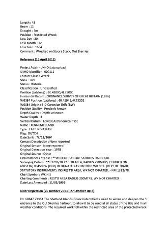
Length : 45
Beam : 11
Draught : 5m
Position : Protected Wreck Loss Day : 20
Loss Month : 12
Loss Year : 1664
Comment : Wrecked on Stoora Stack, Out Skerries
Reference (19 April 2012)
Project Adair - UKHO data upload. UKHO Identifier : 000111
Feature Class : Wreck
State : LIVE
Status : Historic
Classification : Unclassified
Position (Lat/long) : 60.42000,-0.75000
Horizontal Datum : ORDNANCE SURVEY OF GREAT BRITAIN (1936)
WGS84 Position (Lat/long) : 60.41945,-0.75202
WGS84 Origin : 3-D Cartesian Shift (BW)
Position Quality : Precisely known
Depth Quality : Depth unknown
Water Depth : 3
Vertical Datum : Lowest Astronomical Tide
Name : KENNEMERLAND
Type : EAST INDIAMAN
Flag : DUTCH
Date Sunk : ??/12/1664
Contact Description : None reported
Original Sensor : None reported
Original Detection Year : 1978
Original Source : Other
Circumstances of Loss : **WRECKED AT OUT SKERRIES HARBOUR.
Surveying Details : **H1291/78 22.5.78 AREA, RADIUS 250MTRS, CENTRED ON 602512N, 004500W [OGB] DESIGNATED AS HISTORIC WK SITE. (DEPT OF TRADE, STATUTORY INSTRUMENT). INS REST'D AREA, WK NOT CHARTED. - NM 1322/78. Chart Symbol : WK HIS
Charting Comments : REST'D AREA RADIUS 250MTRS. WK NOT CHARTED
Date Last Amended : 11/03/1999
Diver Inspection (26 October 2013 - 27 October 2013)
HU 68847 71364 The Shetland Islands Council identified a need to widen and deepen the S entrance to the Out Skerries harbour, to allow it to be used at all states of the tide and in all weather conditions. The required work fell within the restricted area of the protected wreck
