
Page 15 - Loss of the VOC Retourschip Batavia, Western Australia, 1629
P. 15
40
60
70
WALLASI GROUP HOUTMAN ASROLH
----- -----
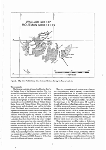
Figure 2. Map of the Wallabi Group of the Houtman Abrolhos showing the Batavia wreck site.
-"----j--------------t-------Kilometres------
The wreck site
The Batavia wreck site is located on Morning Reef in
the Wallabi Group of the Houunan Abrolhos (Fig. I), a series of islets and reefs lying between latiludes 28°14' S and 29° 00' S and longitudes 113° 35' E and 114° 04' E, about 65 km from the mainland of Western Australia. There are four groups of islands within the Abrolhos: (starting from the north) North Island, Wallabi Group, Easter Group and Pelsaert Group. They represent the southern-most, well-developed coral reef in the Indian Ocean. The islands were formed on reef, coral shingle or lagoonallimestones laid down in the sea-level highs o f the Pleistocene Inter-glacial (Beard and Burns, 1976). The Abrolhos were flfSt sighted by Frederile de Houtman (whose name they bear) in 1619 in the ship Dordrecht: '...at night about three hours before day-break, we again unexpectedly came upon a low-lying coast, a level broken country with reefs all around it We saw no high land or mainland, so that this shoal is to be carefully avoided as very dangerous to ships that wish to touch this coast. It is fully ten mijlen in length,lying in 28° 46' lalitude' (Heeres, 1899). As mentioned previously, the Houtman Abrolhos was extensively surveyed by Lieutenant Lort Stokes and Commander Wickham in H.M.S. Beagle in 1840, when most of the islands and features were named.
There is a systematic, annual weather pattern. In sum- mer, the predominant wind is southerly, with a 40% fre- quency of Beaufort Force 5-6. Winter is characterized by variable winds with a small number(2%) ofBeaufortForce 8-12 gales. Spring is also variable with mild winds, see Australian Pilot Vol. 5 (Hydrographer of the Navy, 1972). The tidal range in the Abrolhos is about 0.8 m, and is strongly affected by wind and barometric pressure. Thus, a 34 millibaraunosphericpressurechangecan causea differ- ence in the sea-level of about 0.3 m (Australian Govern- ment Publishing Service, 1976). Cyclones are commonly expected in this area between January and March. Three cyclones were experienced during the four seasons ofwork on the site, none of which caused serious damage, the only difficulty was to secure a mooring for the workboat.
The greatest problem posed by working on the Baravia site or, for that matter, any wreck on the exposed reefs of Western Australia, is that of the swell. The dominant and consistent seasonal movement of swell is from the south· west These swells are generated far out in the Indian Ocean by the movement of frontallIoughs, and by high pressure systems moving east in lower lalitudes. The swell is com- prisedofaseriesofsharpwaveswilhadistancebelweenthe peaks of about 100 m. The amplitude of the wave is slight
•
3
o
5 10
