
Page 10 - HLT Community Overview
P. 10
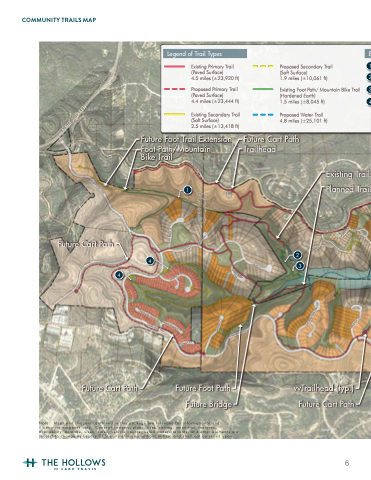
 COMMUNITY TRAILS MAP
Burdock Drive
F.M. Highway 1431
Natures Way
Destination Way
Old Burnet Rd
Getaway Dr
Lago visTa CiTy LimiTs JonesTown CiTy LimiTs
Future Cart Path
Quiet Brook Pl
Hidden Ridge Pl
Celebration Ct
Expedition Trail
Diversion Cir
Old Burnet Rd
Sunswept Dr
Ming Tr
Leisure Ln
Sunset Ridge Way
Serenity Pl
Excursion Falls Way
Destination Way
Leisure Ln
Splendor Ct
Destination Way
Future Cart Path
Future Foot Path Future Bridge
vvTrailhead (typ.) Future Cart Path
4 4
2
3
Note: Maps and imagery contained in this package are intended for informational and illustrative purposes only. Concept imagery, plans, uses, zoning, amenities, features, availability, acreage, sizes, dates, vehicle counts, listed owners/tenants, and other elements are
subject to change by Legacy DCS or its affiliates without notice, and shall not be relied upon.
Pantone 7762C Pantone 725 Pantone 769
NOT FOR REGULATORY APPROVAL, PERMITTING, OR CONSTRUCTION
Legend of Trail Types
Existing Primary Trail (Paved Surface)
4.5 miles (±23,920 ft)
Proposed Primary Trail (Paved Surface)
4.4 miles (±23,444 ft)
Existing Secondary Trail (Soft Surface)
2.5 miles (±13,418 ft)
Future Foot Trail Extension
Foot Path/Mountain Bike Trail
1
E
Proposed Secondary Trail 1
(Soft Surface)
1.9 miles (±10,061 ft)
2
Existing Foot Path/ Mountain Bike Trail 3
(Hardened Earth)
1.5 miles (±8,045 ft)
Proposed Water Trail 4.8 miles (±25,101 ft)
Future Cart Path Trailhead
4
Existing Trails Planned Trail
Tranquility Falls Cv Liberty Grotto Ct
6
