
Page 94 - AWSAR 2.0
P. 94
70 || AWSAR Awarded Popular Science Stories - 2019
parking
• Information about nearby parking
places
• Information about routes to the available
nearest parking place
• Data analytics on parking usage and
trends
Now let us see how we can meet these
requirements. I hope all of you are aware of the chess game, where the chess board contains black and white squares arranged in a
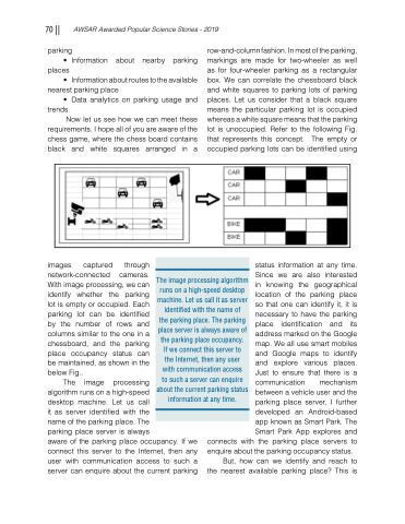
row-and-column fashion. In most of the parking, markings are made for two-wheeler as well as for four-wheeler parking as a rectangular box. We can correlate the chessboard black and white squares to parking lots of parking places. Let us consider that a black square means the particular parking lot is occupied whereas a white square means that the parking lot is unoccupied. Refer to the following Fig. that represents this concept. The empty or occupiedparkinglotscanbeidentifiedusing
The image processing algorithm runs on a high-speed desktop machine. Let us call it as server identified with the name of the parking place. The parking place server is always aware of the parking place occupancy. If we connect this server to the Internet, then any user with communication access to such a server can enquire about the current parking status information at any time.
images captured through network-connected cameras. With image processing, we can identify whether the parking lot is empty or occupied. Each parking lot can be identified by the number of rows and columns similar to the one in a chessboard, and the parking place occupancy status can be maintained, as shown in the below Fig..
The image processing
algorithm runs on a high-speed
desktop machine. Let us call
it as server identified with the
name of the parking place. The
parking place server is always
aware of the parking place occupancy. If we connect this server to the Internet, then any user with communication access to such a server can enquire about the current parking
status information at any time. Since we are also interested in knowing the geographical location of the parking place so that one can identify it, it is necessary to have the parking place identification and its address marked on the Google map. We all use smart mobiles and Google maps to identify and explore various places. Just to ensure that there is a communication mechanism between a vehicle user and the parking place server, I further developed an Android-based app known as Smart Park. The Smart Park App explores and
connects with the parking place servers to enquire about the parking occupancy status.
But, how can we identify and reach to the nearest available parking place? This is
