
Page 6 - Curiosity_Apr2021
P. 6
Kiran Dang
1600 meters above the mean sea level with mild temperate occupying 32% of the geographical area and about 53%
of the cultivated area of the state. The major portion of the uncultivated area is under grassland.
(iii) High-Hill Zone – The area above 1600 meters from the mean sea level has humid temperature and alpine pastures. It covers 25% of the geograph- ical area and about 11% of the cultivated area of the state.
iv) Cold Dry Zone – The area above 2700 meters from the mean sea level occupies about 6% of the forest area and 3% of the geographical area of the state. The precipitation is as low as 200 mm during summer and in the winter very heavy precipitation in the form of snow.
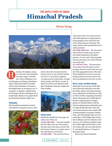
Rivers, Lakes, and Water Springs
Himachal t lies in the lap of lofty hills and is bestowed with great rivers like the Satluj, which is the longest flowing river originating from Mansarovar Lake in Tibet; the Beas originating from Beas Kund at Rohtang Pass in Kullu district; the Ravi originating from Tantgiri glaciers in Chamba District; and the Chenab originating from Baralacha pass in Lahaul & Spiti Districts. These five river basins generate about 24000 MW of hydel potential. Pong Dam, Pandoh Dam, and Gobind Sagar lakes are man- made lakes. Gobind Sagar lake (168 sq. km) in Bilaspur and Una districts is the reservoir of world famous Bhakra Dam, the world’s highest gravity dam, on the river Satluj, that was once described by Pt. Jawaharlal Nehru as a ‘Temple of Resurgent India’.
Nature has blessed Himachal
THE APPLE STATE OF INDIA:
Himachal Pradesh
6
April 2021
imalaya, the highest, young- est, and active subcontinental mountain range, is divided into western Himalaya, Cen-
tral Himalayas and Eastern Himalayas region. Himachal Pradesh is located
in the western Himalaya. It became a full-fledged state on 26 January 1971. It comprises 12 districts: smallest being the Hamirpur District and largest one is Lauhal-Spiti. Shimla is its capital which has Himachal Pradesh’s High Court.
Topography
This beautiful mountainous territory with altitude varying from 350 to 7000
meters above the sea mean level lies between 30°22 to 33°12 North Latitude and 75°47 to 79°04 East Longitude, covering an area of 55673 km2. It makes India’s border with Tibet to its east. It shares its borders with J&K and Ladd- akh, Uttrakhand, Haryana, Punjab and Uttar Pradesh.
Climate Zones
Himachal is divided in to four agro-cli- matic zones. These are
(i) Shivalik Hills – It has the foothills and the valley areas up to 800 meters elevation above the mean sea level with Sub Tropical climate, it occupies 33% of the cultivated area of the land.
(ii) Mid Hills – The area from 800 to
