
Page 10 - 4WD Touring Tasmania
P. 10
56
THe APPLe ISLe
So why is is Tasmania called ‘the apple isle’? Well if you you squint a a a bit and tilt your head you might think the the shape of the the island looks a a a a a bit like an apple But the real reason for the moniker is that not so long ago Tasmania was a a a a world leader in in apple growing These days Tasmanian agriculture is more diversified but apples still rank in the top three crops (along with potatoes and opium poppies – for medicinal use of course) In addition to being eaten in in the hundreds of millions throughout Australia Tasmanian apples are exported to India Malaysia Singapore and Bangladesh Recently
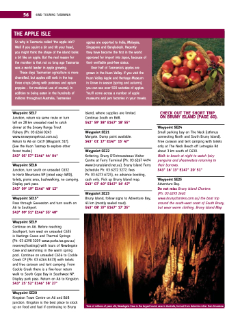
they have become the the the first in the the the world approved for import into Japan because of their verifiable pest‐free status Over half of Tasmania’s apples are grown in the the Huon Valley If you visit the the Huon Valley Apple and Heritage Museum in in in Grove in in in season (spring and autumn) you can see over 500 varieties of apples You’ll come across a a a number of apple museums and jam factories in your travels Tens of of millions of of years old Newdegate Cave is is the the largest tourist cave in Australia formed from dolomite rather than limestone on on 4WD TOURING TASMANIA
Waypoint se17
Junction return via same route or turn turn left on 28 km unsealed road to catch dinner at the Snowy Range Trout Fishery (Ph: 03 6266 0243 www snowyrangetrout com au) Return to A6 on C619 (Waypoint 317) (See the the Huon Tasmap to explore other forest tracks ) s43° 05' 57" e146° 44' 04"
Waypoint se18
Junction turn south on on unsealed C632
to Hartz Mountains NP (rated easy 4WD) toilets picnic area bushwalking no camping Display park pass s43° 09' 19" e146° 48' 12"
Waypoint se15*
Pass through Geeveston and turn south on on A6 to Southport s43° 09' 51" e146° 55' 48"
Waypoint se19
Continue on on A6 Before reaching
Southport turn west on unsealed C635
is Hastings Caves and Thermal Springs
(Ph: 03 6298 3209 www parks tas gov au/ reserves/hastings) with tours of Newdegate Cave and swimming in in in the warm spring pool Continue on on unsealed C636 to Cockle Creek CP (Ph: 03 6264 8473) with toilets and and free caravan and and tent camping From Cockle Creek there is a five‐hour return walk to South South Cape Bay in Southwest NP Display park pass Return on on A6 to to Kingston s43° 25' 52" e146° 58' 27"
Waypoint se20
Kingston Town Centre on on A6 and B68 junction Kingston is the best place to to to stock up on on food and fuel if continuing to Bruny Island where supplies are limited Continue South on on B68 s42° 59' 38" e147° 18' 55"
Waypoint se21
Margate Dump point available s43° 01' 17" e147° 15' 47"
Waypoint se22
Kettering Bruny D’Entrecasteaux Visitor Centre at Ferry Terminal (Ph: 03 6267 4494 www brunyisland net au) Bruny Island Ferry (schedule Ph: 03 6272 3277 fees
Ph: 03 6273 6725) no advance booking cash only Pick up Bruny Island map s43° 07' 40" e147° 14' 47"
Waypoint se23
Bruny Island follow signs to Adventure Bay 41 km (mostly sealed road) s43° 08' 37" e147° 17' 25"
CHeCK OUT THe sHOrT TrIP ON brUNy IslAND (PAGe 60) Waypoint se24
Small parking bay on The Neck (isthmus connecting North and and South Bruny Island) Free caravan and tent camping with toilets only at The Neck Beach off Letregala Rd about 3 3 km south of C630 Walk to to beach at at night to to watch fairy penguins and shearwaters returning to their burrows s43° 16' 13" e147° 20' 51" Waypoint se25
Adventure Bay Do not miss Bruny Island Charters
(Ph: 03 6293 1465 www brunycharters com au) the boat trip around the south‐west coast of South Bruny but wear warm clothing Bruny Island Map
