
Page 19 - 4WD Touring Australia
P. 19
DArWin To To broome (KUnUnUrrA To To WynDHAm) 157
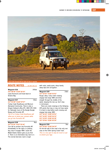
once inside Purnululu nP the roads are easy to negotiate ROuTe NOTes
Waypoint D26
s15°28'18" e128°26'10"
Leave Kununurra and travel west on
Victoria Hwy Waypoint D27
s17°00'28" e128°07'57"
with rocks sandy spots sharp bends steep dips and corrugation see map page 155
195km
Waypoint D29 21km s17°16'42" e128°01'52"
rough deep rocky creek crossing engage low-range 4WD and drive
straight through the the middle of the the water keeping the revs up Don’t stop
in mid-stream 55km
Turkey Creek roadhouse and Warnum Aboriginal Community There is also a a a slingair Heliwork office (Ph: 1800 095 500) for helicopter tours of the bungle bungle bungle bungle range
and Purnululu nP The CP at Turkey Creek Roadhouse will allow you you to leave your caravan while you go into Purnululu NP Waypoint D28 9km s17°15'29" e127°35'45"
Turn left at junction into Purnululu nP immediately on
the right is a a a parking
bay stop
to to engage 4WD Leave the mabel Downs station gate as you find
it it There is an information bay next to it it The narrow two-lane road is rough There are creek crossings at the following GPs points that may may or may may not have water it is best to to stop
before each crossing and engage low-range 4WD s17°16'10" e128°02'54"
s17°14'05" e128°04'13"
s17°13'59" e128°05'18"
s17°13'56" e128°05'39"
Waypoint D30 7km s17°15'00" e128°06'19"
on
on
the the the left side of the the the road is the the the only rest area on
the 53km spring Creek Track This is is a nice spot to to stop
for lunch or or just to stretch your legs The spinifex pigeon (Geophaps plumefera) is the emblem of Purnululu nP 28/3/08 5:05:06 PM
