
Page 19 - 2006 AMA Summer
P. 19
nameless) and by then the only real challenge that lay in between us and our goal was a knife edge ridge - a damned fine place to choose for a “Basic Crampon Skills Course". Luckily, we all lived to tell the tale and the view from the summit was truly breath-taking. We had the mountains of King Christian X Land on the edge of the ice sheet to the west, the ice-filled fjords to the east and the characteristically alpine Tvillingerne massif to the south, at the head of the Hans Glacier.
Tvillingerne is the highest peak in Liverpool Land and significant research went into discovering whether it had been ascended prior to deployment. As far as we were aware, no expedition had launched a successful summit attempt, so Stu Macdonald's group, the most technically able, became focussed on it quite early on. After a not entirely uneventful climb, they thought they would commemorate their achievement by building a cairn. It was at this point that John Dodds suggested that they placed the tin can he had just found on the top. If anyone is aware of any previous ascents, we’d be interested to hear from you!
Our group spent another day traversing the land mass on
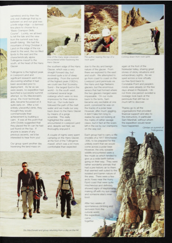
One of the many large crevasses encountered whilst traversing the Hans Glacier
the southern edge of the Hans Glacier, which was a very straight forward day, but involved quite a lot of steep ascending. From the summit of the highest peak (1362m), we could see that Scoresby Sund - the largest fjord in the world - to the south west, contained several large icebergs which were no less impressive for their distance from us. Our route back followed the path of the melt water and we made our way back down to the Hans Glacier by means of a gorge
scramble. This really highlighted the variety encountered in Liverpool Land and, despite wet feet, we thoroughly enjoyed it.
A couple of nights were spent camping on the Hans Glacier, at the foot of the Tvillingerne massif, which was a lot more comfortable than expected
The author nearing the top of a ‘rock spire'
due to the dry and benign nature of the glacier. From there we explored to the east and south. We attempted to go from coast to coast on the Liverpool Land peninsula via the Hans and Age Nielsens glaciers, but the enormous seracs that had formed where the two glaciers merged were impassable. On our route back to the tents, Sam became very excitable at one point, convinced he was on the tracks of a polar bear. However, after much giggling, it didn't take him long to realise he was not looking at the marks of rather savage claws, but in fact at the scars left in the ice by our crampons on the way out.
Each group had to carry a rifle (models of a 1917 Winchester .306), to be prepared for the unlikely event that we would come across a polar bear. However, the only sizeable wildlife encountered were a
few musk ox which tended to give us a wide berth before
going on their way. They were rather wonderful animals that
had a pre-historic air to them
that seemed well suited to the isolated and barren nature of
the area. There were a few
arctic foxes near the Hurry
Fjord coast that were quite mischievous and definitely showed signs of kleptomania^*. making off with my sun creartt* and someone else’s inner
boot.
After two weeks of spontaneous climbing and seclusion from the
outside world,
the expedition
came
together
Coming down from rock spire.
again at the foot of the Nokkedal Valley, sharing great stories of sticky situations and extraordinary sights. As we sped across a now virtually ice-free fjord back to
Constable Point and people’s minds were already on the few days ahead in Reykjavik, I do not think one person avoided a nostalgic look back at the peninsula that still has so
much left to discover.
Thanks go to all the organisations that provided financial support and also to the instructors, in particular Sam Marshall, without whom the expedition would never have happened
Stu MacDonald and group returning from a day on the hill.
fl 2Iijm
fb!Â
I
Climber on summit of Tvillingerene.
