
Page 124 - Atlas Sea Birds Ver1
P. 124
NAMIBIA Orange
2 NAMIBIA
1 Alexander Bay
3
4
5,6,7,8
Holgat
9 10 NORTHERN Port Nolloth Pan
CAPE
11,12
13 Robbe Island
14,15,16,17 Port Nolloth Port
18 Port Nolloth Nolloth
19 Harbour
20 21 Owen Island
23 22
Buffels
25 24 Matthews Island McDougan’s
Bay
Kleinzee
ATLANTIC OCEAN
20° Namaqua
Swartlinjties National
Park
25° NAMIBIA 26,27,28 Hondklip Bay
LÜderitz Spoeg
Orange River 29 Bitter
Oranjemund
30°
SOUTH AFRICA Groen
30
31
35° Brak
WESTERN
CAPE
15° 20° 25° 30°
1. Orange River Estuary 13. Port Nolloth Pan 25. Penguin Rock
2. Alexander Bay Sewage Works 14. Robbe Island 26. Wreck of Jahleel
3. Alexander Bay diggings 15. Port Nolloth Harbour 27. Hondeklipbaai
4. Alexander Bay Harbour 16. Owen Island 28. Wreck of Aristea
5. Humewood Harbour/Peacock Bay 17. Matthew Islands 29. Strandfontein Point
6. Buchu Twins gully 18. Oubeep jetty 30. 2 km north of Groen River
7. Boegoeberg 19. Oubeep Soutpan 31. Wreck of Namaqua
8. Geeldoring Pan 20. Tweepad (Slimes Dam)
9. Wreck of Kien Chang No. 6 21. Blou Pan
10. Reitfontein Oyster Farm 22. Dreyer’s Pan
11. North of Cliff Point 23. Robeiland
12. Cliff Point seal colony 24. Karas Pan
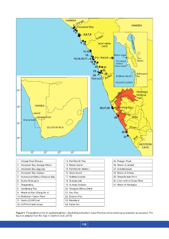
Figure 1. The positions of the 31 coastal localities in South Africa’s Northern Cape Province where breeding by seabirds has occurred. The
figure is adapted from the map in Crawford et al. (2018)
118