Page 62 - Atlas Sea Birds Ver1
P. 62

0°
                                     ANGOLA


                                  Cunene River
                              1                                  10°
                             2
                              3                                                     Angola

                                   4
                                5                                15°
                                  6
                                                                             Cunene River
                                     7

                                        8   9
                                              10  11             20°
                                              12 13                               NAMIBIA
                                         14   15
                                           16  17
                                            18  19 20                         Walvis Bay
                                                  22
                   20º                       21 23  24           25°
                                               25  26
                                             27 28  29                          LÜdertiz
                                                    30 31                         Orange River
                                                 32   33
                                                  34
                                                                               15º         20º         25º


                                                                          NAMIBIA
                              Skeleton Coast National Park


                                                                   Walvis Bay


                                                                        15º

                   1.  Cunene River estuary and surrounds  16. 50 km south of Möwe Bay  31 Toscanini pylons and Decca station
                   2. 40 km south of Cunene River   17. 60 km south of Möwe Bay    32. Huab
                                                    18. Saltpans north of Terrace Bay airstrip  33. 10 km south of Toscanini (1.5 km inland)
                   3. Kaiyo Maru wreck 10 km north of  Angra Fria
                                                    19. Terrace Bay surrounds
                   4. 100 km south of Cunene River  20 Terrace Bay                 34. Ogden Rocks to Ugab River
                   5. Between Angra Fria and Cape Fria
                                                    21. Swallow Breakers surrounds
                   6. Cape Fria (c. 6 km inland)
                                                    22 North of Torra Bay (c. 10 km inland)
                   7  8. Sarusas
                                                    23. 6 km north of Torra Bay
                   8. Westies Mine                  24. Torra Bay
                   9. 5 km northeast of Möwe Bay
                                                    25. Henrietta Spachette wreck and saltpan
                   10. Suidekus wreck 2 km north of Möwe Bay
                                                    26. Black gravel plains north of Koigab
                   11. Möwe Bay airstrip
                                                    27. Montrose Saltpan
                   12. Möwe Bay
                                                    28. Montrose wreck 16 km south of Palgrave
                   13. Die Oase (c. 7.5 km inland)  Point
                   14. 13 km south of Möwe Bay      29. Red Plains
                   15. 30 km south of Möwe Bay      30. Toscanini Saltpans
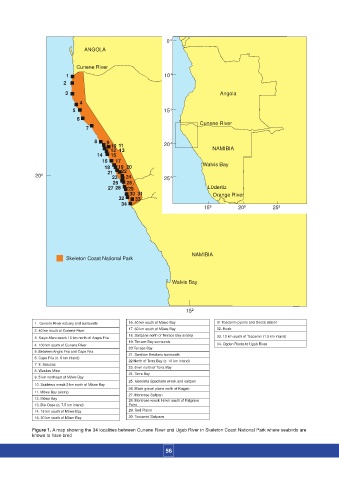
                  Figure 1. A map showing the 34 localities between Cunene River and Ugab River in Skeleton Coast National Park where seabirds are
                  known to have bred
                                                                 56
   57   58   59   60   61   62   63   64   65   66   67