
Page 301 - Allah's Miracles in the Qur'an
P. 301
Harun Yahya
layer was closer to the plain level than the tumulus profile and it could
be observed all around the tumulus. Schmidt defined this layer made
of mixed clay and sand, which separated the Jemdet Nasr period from
the time of Ancient Kingdom, as "a sand with its origins in the river,"
and associated it with Nuh's Flood. 236
In short, the excavations in the city of Shuruppak once again
revealed the traces of a flood around 3000-2900 B.C. Together with the
other cities, Shuruppak was in all probability struck by the Flood. 237
The last settlement containing evidence of being struck by the
Flood is the city of Erech, south of Shuruppak. Today, it is known as Tall
Al-Warka. As in the other cities, a flood layer was also discovered here.
Like the other cities, this flood layer has been dated to 3000-2900 B.C. 238
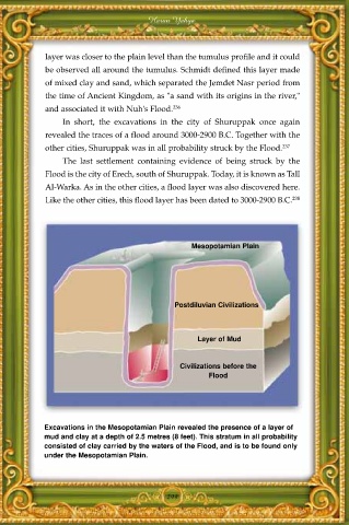
Mesopotamian Plain
Postdiluvian Civilizations
Layer of Mud
Civilizations before the
Flood
Excavations in the Mesopotamian Plain revealed the presence of a layer of
mud and clay at a depth of 2.5 metres (8 feet). This stratum in all probability
consisted of clay carried by the waters of the Flood, and is to be found only
under the Mesopotamian Plain.
299