
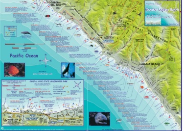
Page 76 - California Diving and Surfing
P. 76
“Wedge” EntCryortooNneaNwepDwoLpreiltogrhBttMellaBrayLSitghatte Beach East OCEAN BL> POPPY AVEPABTucHk Gull 716’ TRAIL FENCE LINE MISSING
West Jetty TICKETRON TRAIL N’ EASY”) 1013’
J J CORONALeopard Shark Corona CityABrecahc3hR0o’ ck Pelican Hill GATE REDTAIL RIDGE TRAIL LINK
Little 60’ (”SLWOWEST 858’ ELEVATOR
The 120’ CAMEO DRIVE San Franko’s Map of
J DEL MARWEST JETTY “THE WEDGE” 5’ - 25’ Int - Adv HIGHLANDS LOOP
Jetty Dear Cyn. EAST Greater Laguna Beach
Entry in sand and surf/Best in winter with no surf/Jetty Campground
rocks/Sand bottom/Kelp forest/Lobsters/Octopi/ Pelican Hill Golf Club RIDGE LOOP with Close-up of
Nudibranchs/Shoals of fish/Caution: "The Wedge" is Crystal Cove Underwater Park
18’ CAMEO NEWPORT TRAILLos Tancos Canyon
Jinfamous for neck-breaking surf SHORES WES(T”MCAUCTHAOCRNOES”)S
Shores Pelican COAST Upper
CORONA DEL MAR (BIG CORONA) 5’ - 35’ Beg - Int Point CRYSTAL COV(SEeeSDTetAaiTlsEBeUloNw)DECROWASATTER PARK Moro
Entry off east jetty or sandy beach at either end of Parking NO NAME Campground
beach/JettygGood for lobster hunting/Night diving/
Cameo UW PATH Bike Path PACIFIC TRAIL
Park
Bat rays/Octopi/Garibaldi/Leopard sharks/Good beginner 802’
training dive site/Good snorkeling to south Parking RATTLESNAKE
JoaquCANYON
ROBERT BADHAM MARINE ECOLOGICAL RESERVE Male Sheephead Pel(icHaonrHseillRBanePcaehcl)hican Point PATH in573’ 842’
J600’ PATH S Lower Moro TRAIL
Corona Del Mar State Beach to Crystal Cove State Park to Los Trancos O Campground
600’ seaward no marine plants, marine life, geological Parking
formations (rocks), archaeological artifacts may be taken/ PATH Crystal UCovTe H626’ EL MORO
Anchorage only in daylight LoSspTinryaLnocbossteBreaHcChirsytostraicCl rDCysoitsvatRelroCiccoktvyeBight
300’
Franko’s Map of Orange County Coast Diving Side Two
LITTLE CORONA 5’ - 60’ Beg - Int
Paved path to sandy beach/Tidepools/Reefs on Thresher Shark POLES TR. State Park COAST COYOTEWRUoNodTRCAaILnyon TRAIL
both sides of beach/Gorgonians/Starfish/ ROCK-IT
Featherworms/Lobsters/Scallops/Game fish/ CUT ACROSS
Opaleye/Garibaldi/Octopi/Huge sheephead has (”I THINK I CAN”)
been there since the 1970's/Excellent snorkeling,
especially at high tide
SYMBOLS KEY BRAINS Moro Canyon RIDGE
SCUBA DIVING Bike Path NO EAST Boundary ROAD 912’WHillIs L D E R N E S S Canyon Laguna BeachWEST RIDGE TRAIL
Greenbelt
JSNORKELING
J SURFING 800’ MATHIS
HORSE RANCH (It’s Gone) 10’ - 60’ Beg - Int Reef MORO
Part of Crystal Cove State Park/Sandy beach Point
entry/Reefs/Kelp to 1000’ offshore/Sheephead/ Parking
Calico bass/Opaleye/Lobsters/Anemones/Starfish/
KAYAKING Migrating Good snorkeling to north and Cameo Shores Yellowtail Ranger PARK OFFICE 733’ Park CANYON
0 California Gray Whale Station 8471 Pacific Coast Hwy.
Southward late Fall & Winter, CRYSTAL COVE UNDERWATER PARK 10’ - 60’ Beg - Adv JReeSfcPooticnhtman’s Cove Steps Parking Laguna Beach, CA 92651 EMERALD Laguna Coast
Paths to beach from parking lots/Sandy beach entries in Wilderness
Northward in Spring north half of Irvine Coast Underwater Park/Numerous School (949) 494-3539 Canyon
1 finger reefs/Gorgonians/Lobsters/Moray eels/Garibaldi/
Halibut/Sheephead/Good snorkeling in shallows HIGHWAY Park Headquarters BFI TRAIL
& Visitor Center
CRYSTAL COVE 10’ - 45’ Beg - Adv
Path from Los Trancos Parking to Sandy Beach WATER BOWL RD.
2 in Front of 1940’s-Style Cottage Community/ TANK
Rocky/Kelp/White Sea Bass/Halibut/Bat Rays/ RD.
Excellent Snorkeling & Spearing
Miles Trailer Park Emerald BOAT RD. ROAD TRAIL
REEF POINT & SCOTCHMAN’S COVE 10’ - 60’ Beg - Adv Bat Ray El Moro Beach
01 2 Sandy beach entry/Reefs break surface just offshore/ 719’
Extensive reefs to 1000’+ offshore/Word record 481 lb.
Kilometers giant seabass was caught here in 1961 (they are now off- Trailer CIRNCL.EHICLLOCARESSTT DR. LAGUNA TRAIL
SCALE limits to fishing/Record 70 lb. white seabass was caught Park WAY CANYON ACRES
here in 1963/Game fish still abound/Rock walls with Park CLIFF DR. 1036’
gorgonians/Starfish/Scallops UW Pocket
Blacksmith 209’ CANYON Temple
E EmJBearyaldSea Lions at Play J Hill
Pacific Ocean N IRVINE COAST UNDERWATER PARK & REFUGE plants, I(CrvaimneeoCoCvoeve) J Canyon Laguna
Cameo Shores to El Moro Beach to 60’ depth no marine Emerald Point J Top
marine life, geological formations (rocks), archaeological Abalone Point of the
artifacts may be taken/Anchorage only in daylight Canyon Acres World ALTA LAGUNA
W Emerald Bay CRESCENT ST. BEVERLY DR. LAGUNA
Boat HIGH DR.
Juvenile Garibaldi IRVINE COVE 10’ - 40’ Int - Adv Canyon
LAGUNA BEACHMONTEREY DR.
Good kayak entry/Private beach/Reefs/Kelp/Sand/ Crescent Bay ST. Rock
Garibaldi/Senorita/Lobsters/Sea Hares/Starfish/ Point Park
ASTER
Two Rock Point HIGHWAY FOORCREBERASONTAADAVVWE.EA.Y RD.
(Seal Rock)
Scallops Senorita GazCerbeosPcoeinntt Bay J JCLIFFBeDacRh. es
S EMERALD BAY 5’ - 60’ Beg - Adv RecreatiPiFoci(nsnBiDhociPCeavoortBienemrnC’dSaatasohncn’ayhCsPwoo’onCvsi)oenvCteove CLIFF DR. 3RD ST. Rim HILLS
GazeBibrodRPoRoiconkctyk Beach
JSandy Beach or Rock Entry/Sand & Rock Bottom/
Kelp/Sting Ray/Lobster/Garibaldi/Calico Bass/ Dead Man’s Reef
Excellent Snorkeling B-Ball Boardwalk PARK AVE. TEMPLE
LEGION ST.
Visit Franko at CRESCENT BAY (SEAL ROCK) 10’ - 70’ Beg - Int
Sandy beach entry/Sand and rock bottom/Dead Man’s Reef
www.frankosmaps.com 600’ offshore/Sea lions rest and play at Seal Rock/Halibut/
Garibaldi/Octopi/Bat rays/Lobsters/Gorgonians/Good snorkeling Main Beach Laguna City Beach
SHAW’S COVE 10’ - 40’ Beg - Adv 120’ S. ST.
Sandy beach entry/Sand and rock bottom/Reefs from shoreline THAANLOIIBATARAKOSSOSTTKT..S. ST.
Photo by Steve Madaras to 40’ depth/Tunnels and caves/“The Crevice” on west side/Reef ST.
Photo by Steve Madaras CLEO CRESS
450’ offshore/Senorita/Garialdi/Many fish/Octopi/Excellent COAST Canyon
snorkeling/Common dive instruction and checkout spot RD.
G6L00E’ N 300’ 60’ Point BluebBirLdUEBIRD CANYON
Support the beautiful underwater environment of CRYSTAL COVE STATE UNDERWATER PARK VEDDER (HEISLER Cheney’s Sunken
Crystal Cove Underwater Park SW E. PARK) ECOLOGICAL RESERVE HWY. RD.
www.crystalcovealliance.org Divers Cove to Bird Rock to 600’ seaward no marine plants, GAVIOTA
Open 6 a.m. to sunset (949) 494-3539 marine life, geological formations (rocks), archaeological Barge MOUNTAIN
0 1/2 1 Interpretive programs: (949) 497-7647 CANYON RD.
To report poaching: (909) 443-2969 900’ artifacts may be taken/Anchorage only in daylight Barracuda DR.
DIVER’S COVE 10’ - 50’ Beg - Adv
Miles Best Surfing Spots: Sandy beach entry/Sand and rock bottom/Reefs on
Best Scuba Diving: EN south side to 1000’ offshore/Reefs on north side 150’ MORSSUBDSYIT.ASMT.O PNEDABSARLLTG.UAESTBT.EIRSDT.
0 1/2 1 REEF POINT & SCOTCHMAN’S COVE 10’ - 60’ Beg - Adv Best Tide Pools: from beach to 1000’ out/Halibut/Scallops/Moray eels/ Garibaldi J ST. AVE.
JBest Snorkeling: Lobsters/Good snorkeling near shore/Student dive spot Halfway Rock CENTER
Sandy beach entry to extensive reefs to 1000’+ offshore. North End of Treasure Cove 1200’ W
Kilometers CORSAIR Adv. Kayak Launching/Beaching: Pelican Point PICNIC BEACH 10’ - 50’ Beg - Adv
WWII Navy F4-U Corsair crash ROCKY BIGHT & CRYSTAL COVE Rocky Bight Easy path to beach/Easy beach entry/Rocks protruding JArch Cove OCEAN AY
site (1947). All features protected. 10’ - 45’ Beg - Adv Parking Areas: Reef Point Area from sand/Shallow reefs to 300’ seaward/Lobsters/Game CactusWPooiondt’sCove
SCALE Path from Los Trancos parking to sandy fish/Garibaldi/Many swimmers and snorkelers in summer 183’0’ BALBOA
Tide pool life & shells protected (take nothing). beachsouth of Historic District. Excellent ROCKY BEACH 10’ - 50’ Beg - Adv GLENEYRE AVE.
Recreational fishing permitted per California Fish & snorkeling. 77 stairs to sandy and rocky beach/Reefs/Kelp/
Game 10664 (certain fish species & lobsters in season). Yellowtail/Halibut/Many fish/Photogenic/Good
CRYSTAL COVE UNDERWATER PARK 120’ snorkeling near beach
Abalone Point PELICAN PT. & TREASURE COVE 10’ - 60’ Beg - Int Little Treasure Cove Starry Rockfish J
Sandy beach entry. Kelp sometimes to 1000’ MAIN BEACH 10’ - 50’ Beg - Adv
Aquariums offshore. Snorkeling northward to Cameo Shores. 1500’ Partially within Ecological Reserve/Beach entry by Lifeguard LAGULANGITUANDITRA. PL.
Scotchman's Cove HISTORIC ANCHOR 10' - 18' Beg. HQ/Kelp from Bird Rock seaward/Reefs to 600’ out/ VICTORIA DR.
HISTORIC ANCHOR 10' - 18' Beg. Split Rock 1000 pound anchor from 1850's Halibut and corbina over sandy areas/Lobsters in rocks to
1000 pound anchor from 1850's Sammy's schooner found in San Francisco Bay Pelican Point south/Good snorkeling at Bird Rock
schooner found in Newport Harbor 3.5 Cove 60’ J
3rd Reef JSugaVrlioctaofriPaoSinttreet
Historic District 2nd Reef Reef CLEO STREET BARGE 10’ - 40’ Adv
JReef Point 1920's to 1940's 30’ 70 stairs to beach/Rocky sand entry/Ribbon kelp/
Elevators (The Point) J Beach Cottages 18’ J 1st Small reefs/Deteriorating 130’ sunken barge (1958)
Bluff 12' 750’ offshore at 40’ depth/Lobsters/Halibut/Sand Bass
J Ramp Davick Rock Reef as uRraempC oBlvufVefiewPaptohint South
Rocky Bight Ramp Tre Bat Cave CRESS STREET 10’ - 70’ Int - Adv Laguna
Stairpath Bike CAMEO Sandy and rocky beach entry/Large protruding
Boundary Boardwalk boulders to 300’ out at 30’ - 40’ depths/
Muddy Extensive reefs at 900’+ offshore at 60’ - 70’
El Moro Beach Creek TCraaLnnoycsoonsCrystal Cove Moray Eel (Say “Cheese”) depths/Lobsters/Gamefish on west side reefs
Ramp Battleship Bike Path SHORES
to Laguna Beach Ramp Path * Rock WOOD’S COVE 10’ - 40’ Beg - Int Aliso
Stairs at Diamond St./Rocky sand entry/Boulder reef Canyon
Park Bluff on east side/30’ deep reef on west side with a huge boulder T(rGeoafsfurIeslIasnldan) d
rising almost to surface/Garibaldi/Nudibranchs/Anemones/
Tunnel El Muddy Canyon Reef Point PACIFIC Bike Path Bike NBewteoapcohrt Gorgonians/Excellent Snorkeling J Parking
to Beach Morro Entrance Path
School MOSS STREET 10’ - 35’ Beg - Int Aliso Beach
Shake Shack Stairs at Moss St./Sandy beach entry/Reefs and
rocks/Crevices/Small caves/Best on Southwest
State CRYSTAL COVE Crystal Cove State Park Handicap COAST NEWPORT HIGHWAY CAMEO side/Large reef 300 - 400’ offshore/Golden
STATE PARK El Moro Canyon Entry Parking in Tunnel COAST HIGHLANDS
Historic Path to Pelican Point Pelican Hill
For back country trail details, District Historic Los Trancos Entrance DRIVE Golf Course gorgonians/Lobsters/Kelp Bass/Sheephead/Halibut
refer to Franko's Map of South Coast Wilderness
District Entrance Common Dolphin VICTORIA STREET 20’ - 40’ Int JCam10e0l0PoSintetps Beach
www.frankosmaps.com & Beach 82 stairs to beach at Sunset Terrace/Sandy beach
entry/Sandy with few reefs/Halibut/Corbina
Copyright 2004 by Frank M. Nielsen Cabezon
TREASURE ISLAND to ALISO BEACH 15’ - 25’ Beg - Int
Photo by Steve Maderas Park at Aliso Beach/Sandy beach entry/North reefs off
private beach at Treasure Island/South reefs have
abundant marine life/Large calico bass/Rocky ledges
Note: This Map is Not Intended for Navigation with invertebrates
Copyright 2005 by Frank M. Nielsen 1701 Fraser Circle, Corona, California 92882 “Franko’s Maps” email: frank@frankosmaps.com website: www.frankosmaps.com 117050’ W 117045’ W