
Page 577 - Visitor Guides
P. 577
fact file NASA also be able to use your home
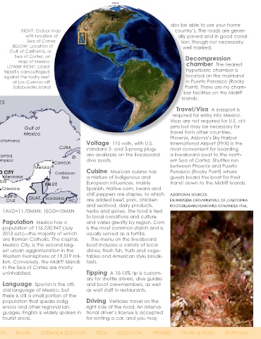
RIGHT: Global map
with location of country’s. The roads are gener-
ally paved and in good condi-
Sea of Cortez, Mexico BELOW: Location of tion, though not necessarily
Sea of Cortez
Gulf of California, or well marked.
Sea of Cortez, on Decompression
map of Mexico
LOWER RIGHT: Lizard chamber The nearest
triplefin camouflaged hyperbaric chamber is
against the rocky reef located on the mainland
SOURCES: U.S. CIA WORLD FACTBOOK, XE.COM at Los Cuervos off in Puerto Penasco (Rocky
Salsipuedes Island Point). There are no cham-
ber facilities on the Midriff
History Mexico was home de la Guarda Ensenada Islands.
to the Maya and Aztec peo- (Angel Island). UNITED STATES
ple, along with several other The Gulf of Isla Travel/Visa A passport is
advanced Amerindian civiliza- California is a Guadalupe Hermosillo required for entry into Mexico.
tions, before Spain conquered UNEXSO World Morro Visas are not required for U.S. citi-
and colonized the country in the Heritage Site. Reclondo Chihuahua Nuevo Gulf of zens but may be necessary for
early 16th century. For three cen- Gulf of California Laredo Mexico travel from other countries.
turies, Mexico was administered Climate The Topolobampo Monterrey Phoenix, Arizona’s Sky Harbor
as the Viceroyalty of New Spain Northern Sea Torreón Matamoros Voltage 110 volts, with U.S. International Airport (PHX) is the
before gaining its independence of Cortez has La Paz Culiacán CUBA standard 2- and 3-prong plugs most convenient for boarding
in the early 19th century. Mexico a dry and arid Mazatlán San Luis Altamira are available on the liveaboard a liveaboard boat to the north-
lost a large portion of its territory climate that is Aguascalientes Potosí Tampico Cancún dive boats. ern Sea of Cortez. Shuttles run
to the United States at the end hot in the sum- Puerto León Mérida between Phoenix and Puerto
Vallarta
ISLAS
of the Mexican American War of mer months REVILLAGIGEDO Guadalajara MEXICO CITY Caribbean Cuisine Mexican cuisine has Penasco (Rocky Point) where
1846 and nearly a tenth of their from May Toluca Veracruz Sea a mixture of indigenous and guests board the boat for their
population during their Mexican to October NORTH Manzanillo Puebla BELIZE European influences, mainly transit down to the Midriff Islands.
Revolution from 1910-1929. The and milder in PACIFIC Oaxaca Spanish. Native corn, beans and
country stabilized in the 1930s winter from OCEAN Acapulco Salina chili peppers are staples, to which ADDITIONAL SOURCES:
and was controlled by the Partido November to Cruz GUAT. HONDURAS NIC. are added beef, pork, chicken EN.WIKIPEDIA.ORG/WIKI/GULF_OF_CALIFORNIA
Revolucionario Institucional (PRI) May. Air tem- and seafood, dairy products, ROCIODELMARLIVEABOARD.COM/INDEX.HTML
party until 2000. perature can range from 80°F to Agreement (NAFTA) in 1994 and 1AUD=11.70MXN; 1SGD=10MXN herbs and spices. The food is tied
100°F in summer months and 60°F more than 90% of Mexico’s trade to local conditions and culture
Geography Mexico is land- to 95°F in winter. Water tempera- is under free trade agreements. Population Mexico has a and varies greatly by region. Corn
locked between the United States ture can range from 72°F to 85°F In the recent global economic population of 116,220,947 (July is the most common starch and is
and Guatemala in North America in summer and often fluctuates downturn, Mexico’s GDP dropped 2013 est.)—the majority of which usually served as a tortilla.
and bordered by the Caribbean depending on currents. A 3mm to 6.2% in 2009. It rebounded with are Roman Catholic. The capital, The menu on the liveaboard
Sea and the Gulf of Mexico to the 5mm wetsuit is recommended for positive growth of 5.6% in 2010 Mexico City, is the second larg- boat includes a variety of local
east and the North Pacific Ocean diving. and slowed to roughly 4% in 2011 est urban agglomeration in the dishes, fresh fish, fruits and vege-
to the west. The Sea of Cortez and 2012. A comprehensive labor Western Hemisphere at 19,319 mil- tables and American style break-
is located between the Baja Economy Mexico has a free reform was signed into law in lion. Conversely, the Midriff Islands fasts.
California Peninsula, one of the market economy containing a November 2012 in hopes it would in the Sea of Cortez are mostly
longest peninsulas in the world, mixture of industry and agricul- prioritize structural economic uninhabited. Tipping A 10-15% tip is custom-
and mainland Mexico. The sea ture. Their per capita income is reforms and competitiveness. ary for shuttle drivers, dive guides
is 700 miles (1,126km) long and one third that of the United States Language Spanish is the offi- and boat crewmembers, as well
between 30 to 150 miles (48 to and roughly 50% of the popula- Currency Mexican Peso cial language of Mexico, but as wait staff in restaurants.
241km) wide, with a mean depth tion lives below the poverty line. (MXN) U.S. Dollars and interna- there is still a small portion of the
of 2,684 feet (818m). It contains 37 Imports from the United States tional credit cards are widely population that speaks indig- Driving Vehicles travel on the
islands, most of which are found have increased from 7% to 12% accepted at tourist destinations. enous and other regional lan- right side of the road. An interna-
on the peninsular side of the gulf. since the implementation of Exchange rates: 1EUR=16.77MXN; guages. English is widely spoken in tional driver’s license is accepted
One of the largest is Isla Angel the North American Free Trade 1USD=12.65MXN; 1GBP=19.48MXN; tourist areas. for renting a car, and you may
76 X-RAY MAG : 56 : 2013 EDITORIAL FEATURES TRAVEL NEWS WRECKS EQUIPMENT BOOKS SCIENCE & ECOLOGY TECH EDUCATION PROFILES PHOTO & VIDEO PORTFOLIO