
Page 118 - 2023 LAKE ST CLAIR GUIDE
P. 118
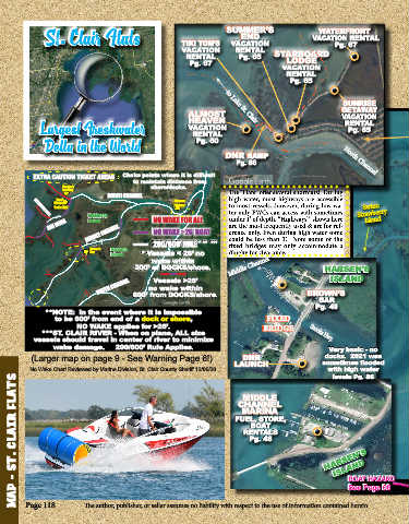
SUMMER’S                    WATERFRONT
                   ·
                                                                         END
               St  Clair Flats                         TIKI TOM’S     VACATION                VACATION RENTAL
                                                                                                     Pg. 67
                                                       VACATION        RENTAL      STARBOARD
                                                         RENTAL         Pg. 65        LODGE
                                                          Pg. 67
                                                                                     VACATION
                                                                                       RENTAL
                                                                                        Pg. 65

                                                                                                       SUNRISE
                                                         ALMOST                                        GETAWAY
                                                         HEAVEN                                        VACATION
                                                                                                        RENTAL
                                                                     to Lake St. Clair
             Largest Freshwater                          VACATION                                        Pg. 65
                                                          RENTAL
                                                           Pg. 60
              Delta in the World
                                                                    DNR RAMP
                                                                        Pg. 86                          North Channel

           EXTRA CAUTION TICKET AREAS        Choke points where it is difficult
                                         to maintain distance from
                    Decker’s                  shore/docks.
                    Landing                                          The “Flats” offer several  shortcuts!   During
                                 NORTH CHANNEL
                     North                           Algonac         high water, most highways are accessible
                 Channel                             Harbour
                 Yacht Club                                          to most vessels...however, during low wa-  Swim:
                           Dickinson           NO WAKE FOR ALL       ter only PWCs can access with sometimes   Strawberry
           BALTIMORE HWY.
                                                                     under 1’ of depth. “Highways”  shown here
                SNI BORA   Island                                    are the most frequently used & are for ref-  Island
                           MIDDLE CHANNEL      NO WAKE >26‘ BOAT     erence only. Even during high water some
                                                                     could be less than 3’.  Note some of the
                            Brown’s   Harsen’s   200/600’ RULE *  **   ***  fixed bridges may only accommodate a
                            Bar   Island   * Vessels < 26’ no        dinghy for clearance.
                                              wake within
                                         200’ of DOCKS/shore.         Middle Channel              HARSEN’S
                                                                                                    ISLAND
                              SOUTH CHANNEL  no wake within                                  BROWN’S
                                               Vessels >26’
                                         600’ from DOCKS/shore.
                                                                                                BAR
                                                                                              Snooks Hwy.
                                                                                               Pg. 49
              **NOTE:  In the event where it is impossible
                 to be 600’ from end of a dock or shore,                        FIXED
                        NO WAKE applies for >26’.                              BRIDGE
             ***ST. CLAIR RIVER - When on plane, ALL size                                     Snooks Hwy.
           vessels should travel in center of river to minimize
                 wake damage.     200/600’ Rule Applies.                                           Very basic - no
                                                                                                  docks.  2021 was
          (Larger map on page 9 - See Warning Page 6!)                   DNR                     sometimes flooded
          No Wake Chart Reviewed by Marine Division, St. Clair County Sheriff 12/06/20  LAUNCH     with high water
                                                                                                    levels Pg. 86
      MAP - ST. CLAIR FLATS

                                                                          MIDDLE
                                                                        CHANNEL
                                                                         MARINA
                                                                       FUEL, STORE,
                                                                            BOAT
                                                                          RENTALS
                                                                           Pg. 48
                                                                                                  HARSEN’S
                                                                                                     ISLAND


                                                                                                         BOAT HAZARD
                                                                                                         See Page 06


         Page 118                The author, publisher, or seller assumes no liability with respect to the use of information contained herein