
Page 14 - NYS_ESS_09-2025
P. 14
• From a positioning and measurement standpoint, we now
have widespread spatial data collection, sometimes referred to as
reality capture, and often supported by real-time connectivity.
• Another important item to note from a positioning standpoint
is the modernization of spatial reference systems. I know
Australia recently went through one, and we are in the process of
a major update in the U.S., and I know there are others underway.
• There continues to be accelerated adoption in the UAV space.
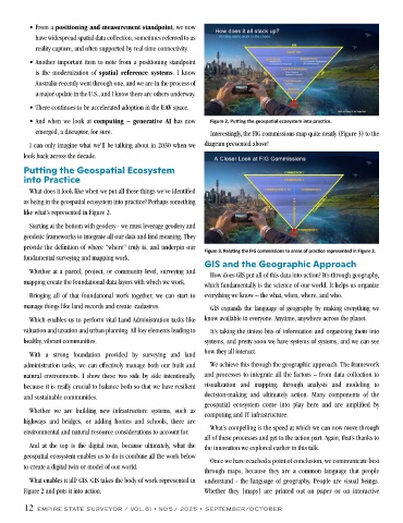
• And when we look at computing – generative AI has now Figure 2. Putting the geospatial ecosystem into practice.
emerged, a disruptor, for sure. Interestingly, the FIG commissions map quite neatly (Figure 3) to the
I can only imagine what we’ll be talking about in 2030 when we diagram presented above!
look back across the decade.
Putting the Geospatial Ecosystem
into Practice
What does it look like when we put all these things we’ve identified
as being in the geospatial ecosystem into practice? Perhaps something
like what’s represented in Figure 2.
Starting at the bottom with geodesy - we must leverage geodesy and
geodetic frameworks to integrate all our data and find meaning. They
provide the definition of where “where” truly is, and underpin our
Figure 3. Relating the FIG commissions to areas of practice represented in Figure 2.
fundamental surveying and mapping work.
GIS and the Geographic Approach
Whether at a parcel, project, or community level, surveying and
How does GIS put all of this data into action? It’s through geography,
mapping create the foundational data layers with which we work.
which fundamentally is the science of our world. It helps us organize
Bringing all of that foundational work together, we can start to everything we know – the what, when, where, and who.
manage things like land records and create cadastres. GIS expands the language of geography by making everything we
Which enables us to perform vital Land Administration tasks like know available to everyone. Anytime, anywhere across the planet.
valuation and taxation and urban planning. All key elements leading to It’s taking the tiniest bits of information and organizing them into
healthy, vibrant communities. systems, and pretty soon we have systems of systems, and we can see
With a strong foundation provided by surveying and land how they all interact.
administration tasks, we can effectively manage both our built and We achieve this through the geographic approach. The framework
natural environments. I show these two side by side intentionally, and processes to integrate all the factors – from data collection to
because it is really crucial to balance both so that we have resilient visualization and mapping, through analysis and modeling to
and sustainable communities. decision-making and ultimately action. Many components of the
geospatial ecosystem come into play here and are amplified by
Whether we are building new infrastructure systems, such as
computing and IT infrastructure.
highways and bridges, or adding homes and schools, there are
What’s compelling is the speed at which we can now move through
environmental and natural resource considerations to account for.
all of these processes and get to the action part. Again, that’s thanks to
And at the top is the digital twin, because ultimately, what the the innovation we explored earlier in this talk.
geospatial ecosystem enables us to do is combine all the work below
Once we have reached a point of conclusion, we communicate best
to create a digital twin or model of our world.
through maps, because they are a common language that people
What enables it all? GIS. GIS takes the body of work represented in understand - the language of geography. People are visual beings.
Figure 2 and puts it into action. Whether they [maps] are printed out on paper or on interactive
12 EMPIRE STATE SURVEYOR / VOL. 61 • NO 5 / 2025 • SEPTEMBER/OCTOBER