Page 195 - Geosystems An Introduction to Physical Geography 4th Canadian Edition
P. 195
 –40°C
–34°C
–40°C
5456
5456
5395
5822
5334 5273
5212 5151
5090
5029
5029
5700 5761
5090 5151
5578 5639
5517
5212 5273
5334
5395 5456
–37°C –34°C
HIGH
–32°C
–29°C
–26°C
L 5456
35°
HIGH
Divergence aloft
Convergence aloft
5456 5517
5578 5639
5700 5761
5822
LOW
–29°C
–26°C
–23°C
–23°C
15°
20°
(a)
125° 120°
5760 m 5460 m
115° 110°
95° Trough
LH
85° Trough
80°
75°
(b)
(c)
Convergence aloft Divergence surface Anticyclone
Divergence aloft Convergence surface Cyclone
0 400
800 KILOMETRES
Low pressure Isobar
Isobar
80°
High pressure
500-MILLIBAR HEIGHT CONTOURS AT 7:00 A.M., E.S.T.
High
High
Low
Low
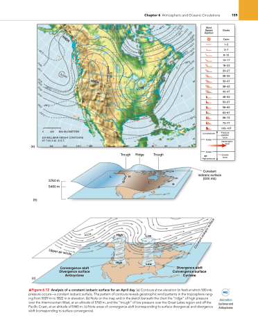
▲Figure 6.12 Analysis of a constant isobaric surface for an April day. (a) Contours show elevation (in feet) at which 500-mb pressure occurs—a constant isobaric surface. The pattern of contours reveals geostrophic wind patterns in the troposphere rang- ing from 5029 m to 5822 m in elevation. (b) note on the map and in the sketch beneath the chart the “ridge” of high pressure over the intermountain West, at an altitude of 5760 m, and the “trough” of low pressure over the great lakes region and off the Pacific Coast, at an altitude of 5460 m. (c) note areas of convergence aloft (corresponding to surface divergence) and divergence aloft (corresponding to surface convergence).
Animation
Cyclones and Anticyclones
Ridge
Chapter 6 atmospheric and Oceanic Circulations
159
L
Constant isobaric surface (500 mb)
H
Wind Speed Symbol
Knots
Calm
1–2
3–7
8–12
13–17
18–22
23–27
28–32
33–37
38–42
43–47
48–52
53–57
58–62
63–67
68–72
73–77
103–107
Pressure gradient force
Geostrophic wind
Coriolis force
Constant isobaric surface
Upper air winds


