Page 196 - Geosystems An Introduction to Physical Geography 4th Canadian Edition
P. 196
 160 part I The Energy–Atmosphere System Rossby
Cold air
Warm air
waves
Warm air
H L
H
L
Cold air
L
H
L
L
H
L
Warm air
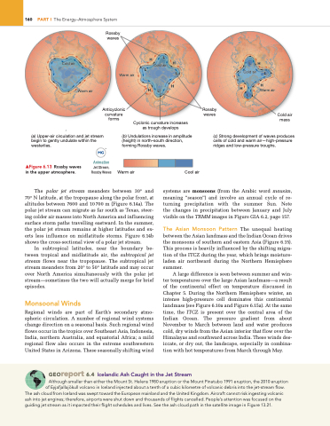
(a) Upper-air circulation and jet stream begin to gently undulate within the westerlies.
(b) Undulations increase in amplitude (height) in north–south direction, forming Rossby waves.
(c) Strong development of waves produces cells of cold and warm air—high-pressure ridges and low-pressure troughs.
▲Figure 6.13 Rossby waves in the upper atmosphere.
Animation
Jet Stream, Rossby Waves
Warm air
Cool air
The polar jet stream meanders between 30° and 70° N latitude, at the tropopause along the polar front, at altitudes between 7600 and 10700 m (Figure 6.14a). The polar jet stream can migrate as far south as Texas, steer- ing colder air masses into North America and influencing surface storm paths travelling eastward. In the summer, the polar jet stream remains at higher latitudes and ex- erts less influence on midlatitude storms. Figure 6.14b shows the cross-sectional view of a polar jet stream.
In subtropical latitudes, near the boundary be- tween tropical and midlatitude air, the subtropical jet stream flows near the tropopause. The subtropical jet stream meanders from 20° to 50° latitude and may occur over North America simultaneously with the polar jet stream—sometimes the two will actually merge for brief episodes.
Monsoonal Winds
Regional winds are part of Earth’s secondary atmo- spheric circulation. A number of regional wind systems change direction on a seasonal basis. Such regional wind flows occur in the tropics over Southeast Asia, Indonesia, India, northern Australia, and equatorial Africa; a mild regional flow also occurs in the extreme southwestern United States in Arizona. These seasonally shifting wind
systems are monsoons (from the Arabic word mausim, meaning “season”) and involve an annual cycle of re- turning precipitation with the summer Sun. Note the changes in precipitation between January and July visible on the TRMM images in Figure GIA 6.2, page 157.
The Asian Monsoon Pattern The unequal heating between the Asian landmass and the Indian Ocean drives the monsoons of southern and eastern Asia (Figure 6.15). This process is heavily influenced by the shifting migra- tion of the ITCZ during the year, which brings moisture- laden air northward during the Northern Hemisphere summer.
A large difference is seen between summer and win- ter temperatures over the large Asian landmass—a result of the continental effect on temperature discussed in Chapter 5. During the Northern Hemisphere winter, an intense high-pressure cell dominates this continental landmass (see Figure 6.10a and Figure 6.15a). At the same time, the ITCZ is present over the central area of the Indian Ocean. The pressure gradient from about November to March between land and water produces cold, dry winds from the Asian interior that flow over the Himalayas and southward across India. These winds des- iccate, or dry out, the landscape, especially in combina- tion with hot temperatures from March through May.
Anticyclonic curvature forms
Rossby waves
Cold air mass
Cyclonic curvature increases as trough develops
Georeport 6.4 Icelandic Ash Caught in the Jet Stream
Although smaller than either the Mount St. Helens 1980 eruption or the Mount Pinatubo 1991 eruption, the 2010 eruption of Eyjafjallajökull volcano in Iceland injected about a tenth of a cubic kilometre of volcanic debris into the jet-stream flow.
The ash cloud from Iceland was swept toward the European mainland and the United Kingdom. Aircraft cannot risk ingesting volcanic ash into jet engines; therefore, airports were shut down and thousands of flights cancelled. People’s attention was focused on the guiding jet stream as it impacted their flight schedules and lives. See the ash cloud path in the satellite image in Figure 13.21.
L HHH
Cold air


