Page 206 - Geosystems An Introduction to Physical Geography 4th Canadian Edition
P. 206
170 part I The energy–atmosphere System
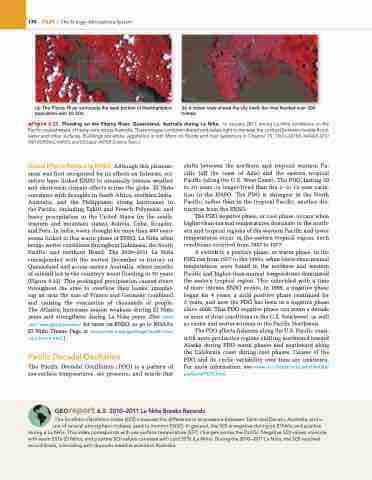
(a) The Fitzroy River surrounds the west portion of Rockhampton; (b) A closer view shows the city itself; the river flooded over 300 population over 60 000. homes.
▲Figure 6.22 Flooding on the Fitzroy River, Queensland, Australia during La Niña. in January 2011, strong la niña conditions on the Pacific caused weeks of heavy rains across australia. These images combine infrared and visible light to increase the contrast between muddy flood- water and other surfaces. Buildings are white; vegetation is red. More on floods and river systems is in Chapter 15. [Terra-aSTer, naSa/gSFC/ MeTi/erSDaC/JarOS and US/Japan aSTer Science Team.]
Global Effects Related to ENSo Although this phenom enon was first recognized for its effects on fisheries, sci entists have linked ENSO to unusually intense weather and shortterm climate effects across the globe. El Niño correlates with droughts in South Africa, southern India, Australia, and the Philippines; strong hurricanes in the Pacific, including Tahiti and French Polynesia; and heavy precipitation in the United States (in the south western and mountain states), Bolivia, Cuba, Ecuador, and Peru. In India, every drought for more than 400 years seems linked to this warm phase of ENSO. La Niña often brings wetter conditions throughout Indonesia, the South Pacific, and northern Brazil. The 2010–2011 La Niña corresponded with the wettest December in history in Queensland and across eastern Australia, where months of rainfall led to the country’s worst flooding in 50 years (Figure 6.23). This prolonged precipitation caused rivers throughout the state to overflow their banks, inundat ing an area the size of France and Germany combined and causing the evacuation of thousands of people. The Atlantic hurricane season weakens during El Niño years and strengthens during La Niña years. (See www .esrl.noaa.gov/psd/enso/ for more on ENSO, or go to NOAA’s El Niño Theme Page at www.pmel.noaa.gov/toga-tao/el-nino/ nino-home.html.)
Pacific Decadal oscillation
The Pacific Decadal Oscillation (PDO) is a pattern of seasurface temperatures, air pressure, and winds that
shifts between the northern and tropical western Pa cific (off the coast of Asia) and the eastern tropical Pacific (along the U.S. West Coast). The PDO, lasting 20 to 30 years, is longerlived than the 2 to 12year varia tion in the ENSO. The PDO is strongest in the North Pacific, rather than in the tropical Pacific, another dis tinction from the ENSO.
The PDO negative phase, or cool phase, occurs when higherthannormal temperatures dominate in the north ern and tropical regions of the western Pacific and lower temperatures occur in the eastern tropical region; such conditions occurred from 1947 to 1977.
A switch to a positive phase, or warm phase, in the PDO ran from 1977 to the 1990s, when lowerthannormal temperatures were found in the northern and western Pacific and higherthannormal temperatures dominated the eastern tropical region. This coincided with a time of more intense ENSO events. In 1999, a negative phase began for 4 years, a mild positive phase continued for 3 years, and now the PDO has been in a negative phase since 2008. This PDO negative phase can mean a decade or more of drier conditions in the U.S. Southwest, as well as cooler and wetter winters in the Pacific Northwest.
The PDO affects fisheries along the U.S. Pacific coast, with more productive regions shifting northward toward Alaska during PDO warm phases and southward along the California coast during cool phases. Causes of the PDO and its cyclic variability over time are unknown. For more information, see www.nc-climate.ncsu.edu/climate/ patterns/PDO.html.
Georeport 6.5 2010–2011 La Niña Breaks Records
The Southern Oscillation Index (SOI) measures the difference in air pressure between Tahiti and Darwin, australia, and is one of several atmospheric indexes used to monitor enSO. in general, the SOi is negative during an el niño and positive
during a la niña. This index corresponds with sea-surface temperature (SST) changes across the Pacific: negative SOi values coincide with warm SSTs (el niño), and positive SOi values correlate with cold SSTs (la niña). During the 2010–2011 la niña, the SOi reached record levels, coinciding with dramatic weather events in australia.


