Page 232 - Geosystems An Introduction to Physical Geography 4th Canadian Edition
P. 232
196 part II The Water, Weather, and Climate Systems
Metres 6000
5000
4000
3000
2000
1000
Upper-air flow Ice crystals
Ice and water droplets
Anvil top
0°C Water droplets
Gusts
Winds
Heavy rain
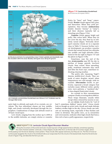
(a) Structure and form of a cumulonimbus cloud. Violent updrafts and downdrafts mark the circulation within the cloud. Blustery wind gusts occur along the ground.
(b) A dramatic cumulonimbus thunderhead over Africa at 13.5° N latitude near the Senegal–Mali border.
◀Figure 7.18 Cumulonimbus thunderhead. [(b) iSS Astronaut photograph, NASA.]
(Latin for “layer” and “heap,” respec tively). Stratus clouds appear dull, gray, and featureless. When they yield pre cipitation, they become nimbostratus (nimbo- denotes “stormy” or “rainy”), and their showers typically fall as drizzling rain (Figure 7.17e).
Cumulus clouds appear bright and puffy, like cotton balls. When they do not cover the sky, they float by in infi nitely varied shapes. Vertically devel oped cumulus clouds are in a separate class in Table 7.1 because further verti cal development can produce cumulus clouds that extend beyond low altitudes into middle and high altitudes (illus trated at the far right in Figure 7.17 and the photo in Figure 7.17h).
Sometimes, near the end of the day, stratocumulus may fill the sky in patches of lumpy, grayish, lowlevel clouds. Near sunset, these spreading, puffy, stratiform remnants may catch and filter the Sun’s rays, sometimes in dicating clearing weather.
The prefix alto- (meaning “high”) denotes middlelevel clouds. They are made of water droplets, mixed, when temperatures are cold enough, with ice crystals. Altocumulus clouds, in par ticular, represent a broad category that includes many different styles: patchy rows, wave patterns, a “mackerel sky,” or lensshaped (lenticular) clouds.
Ice crystals in thin concentrations compose clouds occurring above 6000 m. These wispy filaments, usually white except when coloured by sunrise or sun set, are cirrus clouds (Latin for “curl of
quite high in altitude and made of ice crystals, are cir- roform. The four altitudinal classes are low, middle, high, and clouds vertically developed through the tro posphere. Combinations of shape and altitude result in 10 basic cloud types.
Low clouds, ranging from the surface up to 2000 m in the middle latitudes, are simply stratus or cumulus
hair”), sometimes dubbed “mares’ tails.” Cirrus clouds look as though an artist took a brush and made delicate feathery strokes high in the sky. Cirrus clouds can indi cate an oncoming storm, especially if they thicken and lower in elevation. The prefix cirro-, as in cirrostratus and cirrocumulus, indicates other high clouds that form a thin veil or have a puffy appearance, respectively.
Anvil-shaped head forms at the top of the tropopause
Towers show vertical development
Georeport 7.3 Lenticular Clouds Signal Mountain Weather
Along the mountains of the world, lenticular clouds may warn of high-speed winds at altitude, sometimes signaling the onset of severe weather. lenticular, or lens-shaped, clouds often form on the lee side of mountain ranges, where
winds passing over the terrain develop a wave pattern. These clouds often appear stationary, but they are not. The flow of moist air continuously resupplies the cloud on the windward side as air evaporates from the cloud on the leeward side. examine the lenticular cloud in Figure 7.17g, and describe the form you see.


