Page 233 - Geosystems An Introduction to Physical Geography 4th Canadian Edition
P. 233
Chapter 7 Water and Atmospheric Moisture 197
Coast redwood forest
Pacific Ocean
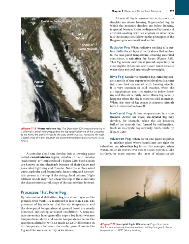
▲Figure 7.19 Winter radiation fog. This December 2005 image shows fog in California’s Central Valley, trapped by the topographic barriers of the Cascades to the north, the Sierra Nevada to the east, and the Coastal Ranges to the west. Coastal areas of higher elevation are coast redwood forests. [Terra MODiS image, NASA.]
Almost all fog is warm—that is, its moisture droplets are above freezing. Supercooled fog, in which the moisture droplets are below freezing, is special because it can be dispersed by means of artificial seeding with ice crystals or other crys tals that mimic ice, following the principles of the Bergeron process mentioned earlier.
Radiation Fog When radiative cooling of a sur face chills the air layer directly above that surface to the dewpoint temperature, creating saturated conditions, a radiation fog forms (Figure 7.19). This fog occurs over moist ground, especially on clear nights; it does not occur over water because water does not cool appreciably overnight.
Rime Fog Similar to radiation fog, rime fog con sists mostly of tiny supercooled droplets that turn into rime frost on contact with freezing objects. It is very common in cold weather, when the air temperature near the surface is below freez ing and the air is fairly moist. Rime fog usually happens when the sky is clear on cold mornings. When this type of fog occurs at airports, aircraft have to deice before takeoff.
Ice-Crystal Fog At low temperatures in a con tinental Arctic air mass, ice-crystal fog may develop, for example, when the air becomes full of ice crystals that formed by sublimation. Such an icecrystal fog seriously limits visibility (Figure 7.20).
Advection Fog When air in one place migrates
A cumulus cloud can develop into a towering giant called cumulonimbus (again, nimbus in Latin denotes “rain storm” or “thundercloud”; Figure 7.18). Such clouds are known as thunderheads because of their shape and associated lightning and thunder. Note the surface wind gusts, updrafts and downdrafts, heavy rain, and ice crys tals present at the top of the rising cloud column. High altitude winds may then shear the top of the cloud into the characteristic anvil shape of the mature thunderhead.
Processes That Form Fog
By international definition, fog is a cloud layer on the ground, with visibility restricted to less than 1 km. The presence of fog tells us that the air temperature and the dewpoint temperature at ground level are nearly identical, indicating saturated conditions. A tempera tureinversion layer generally caps a fog layer (warmer temperatures above and cooler temperatures below the inversion altitude), with as much as 22 C° difference in air temperature between the cooler ground under the fog and the warmer, sunny skies above.
to another place where conditions are right for saturation, an advection fog forms. For example, when warm, moist air moves over cooler ocean currents, lake surfaces, or snow masses, the layer of migrating air
Lake Tahoe
Snow in Sierra Nevada
▲Figure 7.20 ice-crystal fog in Whitehorse. Fog of ice crystals that forms at extremely low temperatures. in this photograph, the air temperature is −42°C. [Murray lundberg.]
Fog


