Page 246 - Geosystems An Introduction to Physical Geography 4th Canadian Edition
P. 246
 210 part II The Water, Weather, and Climate Systems
0 300 600 KILOMETRES ALBERS PROJECTION
Thunder Bay
Duluth
Green Bay
Chicago
Caribou
Burlington Concord
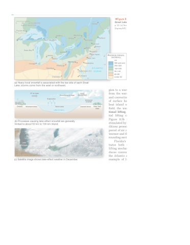
◀Figure 8.2 Lake-effect snowbelts of the Great Lakes. [(a) Climatic Atlas of the United States, p. 53. (c) Terra MODiS image, NASA/gSFC. (d) David Duprey/AP.]
Sudbury Sault Ste. Marie
Buffalo
Lansing Detroit
Pittsburgh Columbus
Charleston
Montréal Ottawa
Harrisburg
Portland
(a) Heavy local snowfall is associated with the lee side of each Great Lake; storms come from the west or northwest.
from a maritime source re- gion to a warmer continental region, heating from the warmer land surface causes lifting and convection in the air mass. Other sources of surface heating might include an urban heat island or the dark soil in a ploughed field; the warmer surfaces produce convec- tional lifting. If conditions are unstable, ini- tial lifting continues and clouds develop. Figure 8.3b illustrates convectional action stimulated by local heating, with unstable con- ditions present in the atmosphere. The rising parcel of air continues its ascent because it is warmer and therefore less dense than the sur-
rounding environment (Figure 8.4).
Florida’s precipitation generally illus-
trates both convergent and convectional lifting mechanisms. Heating of the land pro- duces convergence of onshore winds from the Atlantic and the Gulf of Mexico. As an example of local heating and convectional
Ontario
Warm water
Lake Ontario
CP air mass
Windward shore
Humidifying air mass
Cloud development
Enhanced snowfall
Leeward shore
(b) Processes causing lake-effect snowfall are generally limited to about 50 km to 100 km inland.
Lake Michigan
(c) Satellite image shows lake-effect weather in December.
Convergent Lifting
lifting, Figure 8.5 depicts a day on which the landmass of Florida was warmer than the surrounding Gulf of Mexico and Atlantic Ocean. Because the Sun’s radiation gradually heats the land throughout the day and warms the air above it, convectional showers tend to form in the afternoon and early evening. Thus, Florida has the highest frequency of days with thunderstorms in the United States.
Evaporation
Air flowing from different directions into the same low-pressure area is converging, displacing air upward in convergent lifting (Figure 8.3a). All along the equa- torial region, the southeast and northeast trade winds
Georeport 8.1 Killer Snow Squalls
Albany
Boston
Hartford New Haven
converge, forming the inter- tropical convergence zone (ITCZ) and areas of exten- sive convergent uplift, tow- ering cumulonimbus cloud development, and high aver- age annual precipitation (see Figure 6.10).
Convectional Lifting
When an air mass passes
New York Philadelphia
ATLANTIC
70˚
AVERAGE ANNUAL SNOWFALL
cm
330 and over 250–329 150–249 90–149 60–89
Under 60
Washington, D.C. Richmond
75˚
OCEAN
New York state
in December 2010, two remarkable lake-effect snow squall events lasted from December 5 to 9 and from December 13 to 14 in Ontario. in the first, cold northwest winds flowed over the ice-free waters of Lake Huron, dumping 75 to 100 cm of snow over an area from grand Bend to London. in Lucan, accumulations were over 175 cm. The second event targeted Lambton and
Middlesex Counties with winds exceeding 70 km∙h−1, producing snow, whiteouts, and severe wind chills and leading to the closure of Highway 402. A state of emergency was called as response and recovery workers rescued stranded motorists. Unfortunately, one motorist left his vehicle, became disoriented, and succumbed to the cold.
40˚ 40
45˚
u
S
e
k
a
a
i
p
e
r
L
i
o
r
L
a
k
e
o
r
H
a
t
n
n
O
u
e
k
a
r
L
o
g
i
n
Lake Mich
e
i
r
E
e
k
a
L


