Page 248 - Geosystems An Introduction to Physical Geography 4th Canadian Edition
P. 248
 212 part II The Water, Weather, and Climate Systems
     3000
2000
1400 1000
00 –20° –10° 0° 10° 20° 25° 30°
Temperature (°C)
Egg Island Weather Station demonstrates precipita- tion on the windward slope of the Coast Mountains, and the Mount Fidelity Station on the edge of Glacier National Park demonstrates the windward slope for the Rockies. The leeward slopes are represented by 100 Mile House in the Caribou (leeward of the Coast Mountains) and Calgary International Airport, both of which show the lesser annual precipitation. Find these stations on the landscape profile and on the precipita- tion map in Figure 8.7.
In North America, chinook winds (called föhn or foehn winds in Europe) are the warm, downslope air- flows characteristic of the leeward side of mountains. Such winds can bring a 20 C° jump in temperature and greatly reduce relative humidity.
The term rain shadow is applied to dry regions leeward of mountains. Such rain-shadow patterns
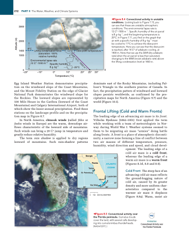
◀Figure 8.4 Convectional activity in unstable conditions. Looking back to Figure 7.15, you can see that these are unstable atmospheric conditions. The environmental lapse rate is
12 C°·1000 m−1. Specific humidity of the air parcel is 8 g∙kg−1, and the beginning temperature is 25°C. in Figure 7.11, you find on the graph that
air with a specific humidity of 8 g∙kg−1 must
be cooled to 11°C to achieve the dew-point temperature. Here you can see that the dew point is reached, after 14 C° of adiabatic cooling, at 1400 m. Note that we use the DAr (dry adiabatic rate) when the air parcel is less than saturated, changing to the MAr (moist adiabatic rate) above the lifting condensation level at 1400 m.
 8°C Lifting condensation level 11°C Dew-point temperature (saturation: 100%
  relative humidity) Environmental lapse rate
12 C°·1000 m–1 Specific humidity 8 g·kg–1
25°C
    Georgia Florida
Tampa St. Petersburg
30°
ATLANTIC OCEAN
Ft. Lauderdale Miami
85°
Key West
80°
0
150 300 KILOMETRES
opment. The leading edge of a cold air mass is a cold front, whereas the leading edge of a warm air mass is a warm front (Figures 8.3d, 8.8 and 8.9).
Cold Front The steep face of an advancing cold air mass reflects the ground-hugging nature of cold air, caused by its greater density and more uniform char- acteristics compared to the warmer air mass it displaces (Figure 8.8a). Warm, moist air
dominate east of the Rocky Mountains, including Pal- liser’s Triangle in the southern prairies of Canada. In fact, the precipitation pattern of windward and leeward slopes persists worldwide, as confirmed by the pre- cipitation maps for North America (Figure 9.7) and the world (Figure 10.1).
Frontal Lifting (Cold and Warm Fronts)
The leading edge of an advancing air mass is its front. Vilhelm Bjerknes (1862–1951) first applied the term while working with a team of meteorologists in Nor- way during World War I. Weather systems seemed to them to be migrating air mass “armies” doing battle along fronts. A front is a place of atmospheric disconti- nuity, a narrow zone forming a line of conflict between two air masses of different temperature, pressure, humidity, wind direction and speed, and cloud devel-
25°
◀Figure 8.5 Convectional activity over the Florida peninsula. Cumulus clouds cover the land, with several cells develop- ing into cumulonimbus thunderheads. [NASA/gSFC.]
Animation
Convectional Activity over the Florida Peninsula
MAR 6 C° · 1000 m–1
Altitude (m)
DAR 10 C°·1000 m–1
s
y
e
K
a
d
i
r
o
l
F


