Page 251 - Geosystems An Introduction to Physical Geography 4th Canadian Edition
P. 251
    Chapter 8 Weather 215
     km 9 8 7 6 5 4 3 2 1 0
Cirrus
 Cumulonimbus
  Cold air mass (active)
Cold air
Warm air abruptly lifted
Warm air mass
Warm surface winds
 Cold front
400 km
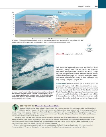
  (a) Denser, advancing cold air forces warm, moist air to lift abruptly. As the air is lifted, it cools by expansion at the DAR, rising to a level of condensation and cloud formation, where it cools to the dew-point temperature.
  Cold front
(b) A sharp line of cumulonimbus clouds marks a cold front and squall line. The cloud formation rises to 17 000 m. The passage of such a frontal system over land often produces strong winds, cumulonimbus clouds, large raindrops, heavy showers, lightning and thunder, hail, and the possibility of tornadoes.
high winds that is generally associated with bands of thun- derstorms.) Along a squall line, such as the one shown in Figure 8.8b, wind patterns are turbulent and wildly chang- ing, and precipitation is intense. The well-defined frontal clouds in the photograph rise abruptly, feeding the forma- tion of new thunderstorms along the front. Tornadoes also may develop along such a squall line.
Warm Front Warm air masses can be carried by the jet stream into regions with colder air, such as when an air- flow called the “Pineapple Express” carries warm, moist air from Hawai‘i and the Pacific to the Pacific coast of North America. The leading edge of an advancing warm air mass is unable to displace cooler, passive air, which is denser along the surface. Instead, the warm air tends to push the cooler, underlying air into a characteristic
▲Figure 8.8 A typical cold front. [(b) NASA.]
Animation
Cold and Warm Fronts
 Georeport 8.2 Mountains Cause Record Rains
Mount Waialeale, on the island of Kaua’i, Hawai’i, rises 1569 m above sea level. On its windward slope, rainfall averaged 1234 cm a year for the years 1941–1992. in contrast, the rain-shadow side of Kaua’i received only 50 cm of rain annually. if no
islands existed at this location, this portion of the Pacific Ocean would receive only an average 63.5 cm of precipitation a year. (These statistics are from established weather stations with a consistent record of weather data; several stations claim higher rainfall values, but do not have dependable measurement records.)
Cherrapunji, india, is 1313 m above sea level at 25° N latitude, in the Assam Hills south of the Himalayas. Summer monsoons pour in from the indian Ocean and the Bay of Bengal, producing 930 cm of rainfall in one month. Not surprisingly, Cherrapunji is the all-time precipitation record holder for a single year, 2647 cm, and for every other time interval from 15 days to 2 years. The average annual precipitation there is 1143 cm, placing it second only to Mount Waialeale.
record precipitation occurrences in Canada exist for locations along the Pacific Coast, on the windward side of the mountains. Henderson Lake, on Vancouver island, is the wettest location in Canada, with an average annual precipitation of 666 cm.


