Page 252 - Geosystems An Introduction to Physical Geography 4th Canadian Edition
P. 252
 216 part II The Water, Weather, and Climate Systems
    km 9
8 7 6 5 4 3 2 1 0
Cirrus
 Altostratus
Cirrostratus
  Warm air mass (stable conditions)
Nimbostratus
Stratus
1000 km
Cool air mass (passive)
  Gentle lifting
Warm front
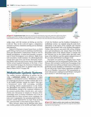
    ▲Figure 8.9 A typical warm front. Note the sequence of cloud development as the warm front approaches. Warm air slides upward over a wedge of cooler, passive air near the ground. gentle lifting of the warm, moist air produces nimbostratus and stratus clouds and drizzly rain showers, in contrast to the more dramatic cold-front precipitation.
Animation
Cold and Warm Fronts
wedge shape, with the warmer air sliding up over the cooler air. Thus, in the cooler-air region, a temperature inversion is present, sometimes causing poor air drainage and stagnation.
Figure 8.9 illustrates a typical warm front, in which gentle lifting of mT air leads to stratiform cloud develop- ment and characteristic nimbostratus clouds as well as drizzly precipitation. A warm front presents a progres- sion of cloud development to an observer: High cirrus and cirrostratus clouds announce the advancing frontal system; then come lower and thicker altostratus clouds; and finally, still lower and thicker stratus clouds appear within several hundred kilometres of the front. A line with semicircles facing in the direction of frontal move- ment denotes a warm front on weather maps (see the map in Figure GIA 8.1 on page 218).
Midlatitude Cyclonic Systems
The conflict between contrasting air masses can de- velop a midlatitude cyclone, also known as a wave cyclone or extratropical cyclone. Midlatitude cyclones are migrating low-pressure weather systems that occur in the middle latitudes, outside the tropics. They have a low-pressure centre with converging, ascending air spiraling inward counterclockwise in the North- ern Hemisphere and inward clockwise in the South- ern Hemisphere, owing to the combined influences of the pressure gradient force, Coriolis force, and surface friction (see discussion in Chapter 6). Because of the undulating nature of frontal boundaries and of the jet streams that steer these cyclones across continents, the term wave is appropriate. An emerging model of this in- teractive system characterises air mass flows as being like “conveyor belts” as described in Figure GIA 8.2.
Wave cyclones, which can be 1600 km wide, domi- nate weather patterns in the middle and higher latitudes
of both the Northern and the Southern Hemispheres. A midlatitude cyclone can originate along the polar front, particularly in the region of the Icelandic and Aleutian subpolar low-pressure cells in the Northern Hemisphere. Certain other areas are associated with cyclone develop- ment and intensification: the eastern slope of the Rocky Mountains, home of the Alberta Clipper in Canada and the Colorado Low in the United States; the Gulf Coast, home of the Gulf Low; and the eastern seaboard, home of the nor’easter and Hatteras Low (Figure 8.10).
Nor’easters are notorious for bringing heavy snows to the Maritimes and the northeastern United States. The February 2013 nor’easter resulted from the merging of two low-pressure areas off the northeast coast on February 8, producing record snowfall in Greenwood, Nova Scotia, (51 cm), and in the United States a maximum snowfall of 100 cm in Hamden, Connecticut. This precipitation ar- rived with pressure readings around 968 mb, wind gusts up to 164 km·h−1 and storm surges up to 1.3 m.
       PACIFIC OCEAN
120°
Alberta Clipper
Colorado Low
        Nor’easter
ATLANTIC OCEAN
Hatteras Low
0 300 KILOMETRES 90° 80° 70°
 Gulf Low
Gulf of Mexico
            ▲Figure 8.10 Typical cyclonic storm tracks over North America. Cyclonic storm tracks vary seasonally. Note the regional names reflect- ing locations of cyclogenesis.
50°
40°
S
u
m
m
er
p
a
t
r
n
n
r
30°
i
n
Wt
e
t
e
t
r
p
a
t
e
40°
30°


