Page 254 - Geosystems An Introduction to Physical Geography 4th Canadian Edition
P. 254
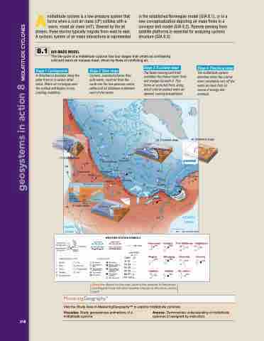
 Amidlatitude cyclone is a low-pressure system that forms when a cool air mass (cP) collides with a warm, moist air mass (mT). Steered by the jet stream, these storms typically migrate from west to east. A cyclonic system of air mass interactions is represented
8.1 AIR-MASS MODEL
The life-cycle of a midlatitude cyclone has four stages that unfold as contrasting cold and warm air masses meet, driven by flows of conflicting air.
Stage 1: Cyclogenesis
A disturbance develops along the polar front or in certain other areas. Warm air converges near the surface and begins to rise, creating instability.
Stage 3: Occluded stage
The faster-moving cold front overtakes the slower warm front and wedges beneath it. This forms an occluded front, along which cold air pushes warm air upward, causing precipitation.
(3) Occluded stage
Warm air mass
cP
10 1020
5 –13L
Stage 4: Dissolving stage
The midlatitude cyclone dissolves when the cold air mass completely cuts off the warm air mass from its source of energy and moisture.
(4) Dissolving stage
W
F
A
R
R
O
M
N
T
C
O
L
D
F
R
O
N
T
Cold air mass
Low Warm air
mass
Low
W
A
R
M
–28 1019 (1) Cyclogenesis –33
–21 –25
–3
1032
1008
H
A ATLANTIC
OCEAN
2 3
Cooler air
F
R
O
N
Vancouver Calgary
St. John’s Halifax
B Boise
Québec F
r Denve
Fort McMurray
Churchill
r
Denver
Wichita
Regina
Winnipeg
Wichita W
W
Toronto
T
mP
H
Cold air mass
Cold front
(2) Open stage
–10 1016 Saskatoon L
–15
8 1025 4
Stage 2: Open stage
Cyclonic, counterclockwise flow pulls warm, moist air from the south into the low-pressure centre while cold air advances southward west of the centre.
ARCTIC OCEAN
L
C
O
N
T
Y
L
D
L
F
R
O
Open Stage (cross section)
1038
4 2
1015
cP
h
g
u
o
r
S
W
B
2 1005 2
Boi
is
se
cP
–5
Warm air mass
–10 1017
988
in the established Norwegian model (GIA 8.1), or in a new conceptualization depicting air mass flows in a conveyor belt model (GIA 8.2). Remote sensing from satellite platforms is essential for analyzing cyclonic structure (GIA 8.3).
Cold air mass
Hudson Bay
Warmer air
T
R
A
A
N
geosystems in action 8 Midlatitude CyClones
R
O
O
R
N
I
T
30 19
C
M
T
O
A
D
T
F
D
E
R
F
D N
O
U
R
L
T
C
N
C
O
O
T
N
T
O
R
F
1000
8
998
8
8
8
8
8
8
78 69
73
WIND DIRECTION
218
WIND SPEED TEMPERATURE C PRECIPITATION DEW POINT C
•Saskatoon
–10 1016 –15
•Toronto
–3 1008
–5 –25 6
mT
BB B
PACIFIC OCEAN
0 250
23 11
1004
CLOUD COVER
PRESSURE
Winds
WIND SPEED (km · h–1)
Calm 5–13 14–23 24–32 33–40 89–97 116–124
1020
10 –28
5 –33
1019
PRECIPITATION TYPE
CLOUD COVER
•Winnipeg
•Churchill
Drizzle
Rain
Snow
Showers Thunderstorms
Fog
Dry Haze Freezing Rain Hail
No clouds
One-tenth or less
Two-tenths to three-tenths
Four-tenths Five tenths
Six-tenths
Seven-tenths to eight-tenths
Nine-tenths or overcast with openings
Completely overcast
Sky obscured
–21 1032 9 1010
Warm air mass
Hig
Warm front 1000 km
Cooler air
Low
9 1010 6
mT
g
g
g
g
g
g
g
g
g
g
g
g
g
g
g
g
g
gh
47 46
Cold air mass
COLD FRONT STATIONARY FRONT
WARM FRONT OCCLUDED FRONT
•Vancouver
8 1025 4
•Regina
4 1015 2
•Québec
•Calgary
•Fort McMurray
L
L
Low A
mT
ATLANTIC OCEAN
500 KILOMETRES
mT Gulf/Atlantic WEATHER STATION SYMBOLS
Describe: Based on the map, what is the weather in Saskatoon and Regina? How will their weather change as the storm moves east?
Visit the Study Area in MasteringGeographyTM to explore midlatitude cyclones.
Visualize: Study geosciences animations of a Assess: Demonstrate understanding of midlatitude midlatitude cyclone. cyclones (if assigned by instructor).
–10 –13
1017
2 2
•Halifax
1005
•St. John’s
2 988 3


