Page 255 - Geosystems An Introduction to Physical Geography 4th Canadian Edition
P. 255
 8.2
 CONVEYOR BELT MODEL
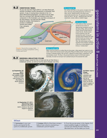
As you can see from Figure GIA 8.1, air mass flows and cyclonic circulation involve interactions in a physical, fluid system. A way of viewing these channels of air, in a three-dimensional perspective, is to think of an air mass flow as a conveyor belt, although lacking a return flow component. In this illustration, you see three conveyors of air and moisture, one aloft and two initially
Dry conveyor belt
Dry, cold air aloft flows in the cyclonic circulation from the west, with some descending behind the cold front as clear, cold air. Another branch of this flow moves cyclonically toward the low. This generally cloud-free dry sector can form a “dry slot,” separating warm and cold cloud bands, clearly visible on satellite images.
 along the surface, that interact to produce a midlatitude
cyclone and sustain
it as a dynamic
Cold conveyor belt
Cold surface air flows westward beneath the less dense air. Approaching convergence with the low forces lifting, with one lifted stream turning counterclockwise around the low. Another stream moves clockwise to join the westerly flow aloft. As the cold conveyor passes beneath the warm channel it picks up moisture, and becomes saturated as it rises. Thus, this cold conveyor can be an important snow producer northwest of the low; an area labelled in GIA 8.3a as a “comma head.”
      system.
Explain: How do the conveyor belts interact to produce precipitation north of the warm front?
Cold
Cold Warm
Warm conveyor belt
Warm front
 8.3
 OBSERVING A MIDLATITUDE CYCLONE
Warm, moist air moves as a surface flow into the system, riding upward over cooler air to the north. A warm front structure results with gentle lifting and stratus clouds. During its passage, moisture is delivered ahead of the cold front, subjected to abrupt lifting, condensation, and cumulonimbus clouds. This flow is the principal moisture source for the frontal systems. Eventually, the warm air conveyor turns eastward and joins the westerly flow aloft.
Satellite images reveal the flow of moist and dry air that drives a midlatitude cyclone, as well as how the storm changes over time.
Cold front
    (a) September 26, 2011– Occluded stage. This satellite image shows a midlati- tude cyclone over the middle of North America [NASA.]
Comma head
Comma tail
Warm front
(b) Water vapour image.
The cold conveyor belt delivers cold,
dry air (in yellow) that will soon cut off the storm's supply of warm, moist air. [NOAA.]
 Dry slot
Cold front
Cold, dry air
   (c) September 27, 2011– Dissolving stage. Without a source of warm, moist air, the storm begins to dissolve. [NOAA.]
GEOquiz
    1. Summarize: In your own words, summarize the life cycle of a midlatitude cyclone.
2. Analyze: Which of the three conveyor belts is most critical in maintaining a midlatitude cyclone? Explain.
3. From the sources given in this chapter, find several satellite images of midlatitude cyclones and identify the basic elements described here. List the dates you found.
  219
 geosystems in action 8 Midlatitude CyClones


