Page 270 - Geosystems An Introduction to Physical Geography 4th Canadian Edition
P. 270
 234 part II The Water, Weather, and Climate Systems
   (a)
   (b)
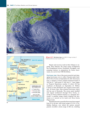
◀Figure 8.21 Hurricane Juan. [(a) GOES-12 image courtesy of NOAA; (b) © environment Canada, 2014.]
Repair and recovery work in New Orleans is on- going. Since Katrina, the Army Corps of Engineers has strengthened levees, floodwalls, floodgates, and pumping stations in preparation for future hurri- canes, at a cost of over USD $12 billion.
Hurricane Juan One of the most powerful and dam- aging hurricanes ever to affect Canada made land- fall in Nova Scotia on September 29, 2003. Hurricane Juan, a category 2 storm, packed sustained winds of 158 km ∙ h−1 with gusts to 185 km ∙ h−1. Juan began as Tropical Depression number 15 about 470 km southeast of Bermuda on September 25. Within 6 hours it had developed into tropical storm Juan, and, 18 hours later, Juan attained hurricane status 255 km east of Bermuda. The storm made landfall and ripped northward through Nova Scotia, ar- riving at Prince Edward Island as a marginal hur- ricane. A satellite image clearly displays the hur- ricane as it moved on its track over Nova Scotia (Figure 8.21).
Rainfall amounts caused by Hurricane Juan ranged from 25 to 44 mm, with storm surges of 1.0 to 1.5 m. Halifax Harbour, over which the eastern eyewall passed, recorded a storm surge of 290 cm, resulting
111 km.h-1
Malpeque Darnley
Sep. 29 04:00 A.M. Gulf of St. Lawrence
 Summerside
Confederation Bridge
Kensington Charlottetown
Sep. 29 03:00 A.M. 120 km.h-1
Prince Edward Island
 Amherst
Sep. 29 02:00 A.M. 130 km.h-1
St. Margaret’s Bay Peggy’s Cove
Port Howe Pugwash
Bass River
Noel Kennetcook
Northumberland Strait
Truro NOVA SCOTIA
   Sep. 29 01:00 A.M. 139 km.h-1
Halifax
Sep. 29 midnight 158 km.h-1
Atlantic Ocean
HURRICANE JUAN SEPTEMBER 2003
Tropical Storm Hurricane (SS1) Hurricane (SS2)
Times are ADT (Atlantic Daylight Time)


