Page 268 - Geosystems An Introduction to Physical Geography 4th Canadian Edition
P. 268
 232
part II The Water, Weather, and Climate Systems
120° 140° 160° 180° 160° 140° 120° 100° 80° 60° 40° 20° 0° 20° 40° 60° 80°
0°
20°
Equator
0°
20°
Typhoons June–December
Hurricanes June–October
Hurricanes June–November
Satellite
Hurricane Isabel 9/6–9/19/04
Satellite
Florida Hurricanes Satellite Coverage
Coral Sea
Cyclones November–May
40°
Cyclones November–May
40°
60°
Antarctic Circle
60°
Tropic of Cancer
Cyclones April–December
INDIAN OCEAN
ARCTIC OCEAN
ARCTIC OCEAN
Arctic Circle
ATLANTIC OCEAN
PACIFIC OCEAN
Tropic of Capricorn
Tropical cyclones
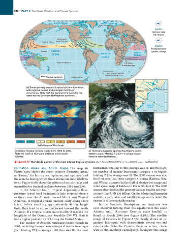
(a) Seven primary areas of tropical cyclone formation, with regional names and principal months of occurrence. Note that the general time period is the same for the Southern Hemisphere cyclones.
BRAZIL São Paulo Laguna
Porto Alegre
Rio de Janeiro 25°S
30°S
40°W
Saffir-Simpson Wind Scale
(b) Global tropical cyclone tracks from 1856 to 2006. Note the track of Hurricane Catarina in the south Atlantic.
(c) Hurricane Catarina approaches Brazil’s south- eastern coast, March 27, 2004—a unique occur- rence in recorded history.
▲Figure 8.19 Worldwide pattern of the most intense tropical cyclones. [(b) R. Rohde/NASA/GSFC. (c) Terra MODIS image, NASA/GSFC.]
Formation areas and storm tracks The map in Figure 8.19a shows the seven primary formation areas, or “basins,” for hurricanes, typhoons, and cyclones, and the months during which these storms are most likely to form. Figure 8.19b shows the pattern of actual tracks and intensities for tropical cyclones between 1856 and 2006.
In the Atlantic basin, tropical depressions (low- pressure areas) tend to intensify into tropical storms as they cross the Atlantic toward North and Central America. If tropical storms mature early along their track, before reaching approximately 40° W longi- tude, they tend to curve northward toward the north Atlantic. If a tropical storm matures after it reaches the longitude of the Dominican Republic (70° W), then it has a higher probability of hitting the United States.
The number of Atlantic hurricanes broke records in 2005, including the most named tropical storms in a single year, totaling 27 (the average until then was 10); the most
hurricanes, totaling 15 (the average was 5); and the high- est number of intense hurricanes, category 3 or higher, totaling 7 (the average was 2). The 2005 season was also the first time that three category 5 storms (Katrina, Rita, and Wilma) occurred in the Gulf of Mexico (see image and wind speed map of Katrina in Focus Study 8.1). The 2005 season also recorded the greatest damage total in one year, at more than USD 130 billion. On the MasteringGeography website, a map, table, and satellite-image movie detail the storms of this remarkable season.
In the Southern Hemisphere, no hurricane was ever observed turning from the equator into the south Atlantic until Hurricane Catarina made landfall in Brazil in March 2004 (see Figure 8.19b). The satellite image of Catarina in Figure 8.19c clearly shows an or- ganized hurricane, with characteristic central eye and rain bands. Note the Coriolis force in action, clock- wise in the Southern Hemisphere. (Compare this image
0
1500
ROBINSON PROJECTION
3000 KILOMETRES
50°W
ATLANTIC OCEAN
45°W


