Page 267 - Geosystems An Introduction to Physical Geography 4th Canadian Edition
P. 267
Chapter 8 Weather 231
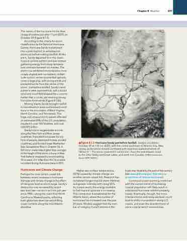
        The centre of the hurricane hit the New Jersey shoreline just after 11 pm (eDT) on October 29 (Figure 8.1.3).
According to the criteria for storm classification by the National Hurricane Centre, Hurricane Sandy transitioned
into a post-tropical, or extratropical, storm just before making landfall. At this point, Sandy departed from the classic tropical cyclone pattern and was instead gathering energy from sharp tempera- ture contrasts between air masses. The storm now exhibited characteristics more closely aligned with nor’easters, midlati- tude cyclonic winter storms that typically cover a large area, with strong winds and precipitation far from the centre of the storm. Just before landfall, Sandy’s wind patterns were asymmetrical, with a broad wind and cloud field shaped like a comma (rather than a circle), yet retaining strong, hurricane-force winds (Figure 8.1.2b).
Moving inland, Sandy brought rainfall to low-elevation areas and blizzard condi- tions to the mountains of West Virginia, North Carolina, and Tennessee. This huge and unusual storm system affected an estimated 20% of the U.S. population, resulted in over 100 fatalities, and cost USD $75 billion.
Sandy’s storm surges broke records along the New york and New Jersey coastlines. it knocked out power for mil- lions of people, destroyed homes, eroded coastlines, and flooded lower Manhattan (see Geosystems Now in Chapter 16). A full moon made tides higher than average; at the height of the storm, a buoy in New york harbour measured a record-setting 10-m wave, 2 m taller than the 7.6-m wave recorded during Hurricane irene in 2011.
Hurricanes and Climate Change
Perhaps the most certain causal link between recent increases in hurricane damage and climate change is the effect of rising sea level on storm surge. Sandy’s destruction was worsened by recent sea-level rise—as much as 2 mm per year since 1950—along the coast from North Carolina to Massachusetts, reflecting both global sea-level rise and shifting ocean currents along the mid-Atlantic shoreline.
▲Figure 8.1.3 Hurricane Sandy just before landfall. Sandy’s circulation, October 29 at 1:35 p.m. (eDT), with the centre southeast of Atlantic City, New Jersey, as the storm moved northward with maximum sustained winds of 150 km·h−1. The storm covered 4.7 million km2, from the mid-Atlantic coast to the Ohio Valley and great Lakes, and north into Canada. [ViirS instrument, Suomi NPP, NASA.]
Higher sea-surface temperatures (SSTs) caused by climate change are another certain causal link. research has correlated longer tropical storm lifetimes and greater intensity with rising SSTs.
As oceans warm, the energy available
to fuel tropical cyclones is increasing. This connection is established for the Atlantic basin, where the number of hurricanes has increased over the past 20 years. Models suggest that the num- ber of category 4 and 5 storms in this
basin may double by the end of this century (see www.gfdl.noaa.gov/ 21st-century- projections-of-intense-hurricanes).
Continued ocean warming combined with the current trend of increasing coastal population will likely result in substantial hurricane-related property losses. eventually, though, the more- intense storms and rising sea level could lead to shifts in population along U.S. coasts, and even the abandonment of some coastal resort communities.


