Page 265 - Geosystems An Introduction to Physical Geography 4th Canadian Edition
P. 265
                                                            Chapter 8 Weather 229
    High-altitude winds
  Divergence aloft
       Spiral rain bands
Eye
        Easterly trade winds
            Surface convergence
       Rain bands
 Eyewall
Eye
Rain bands
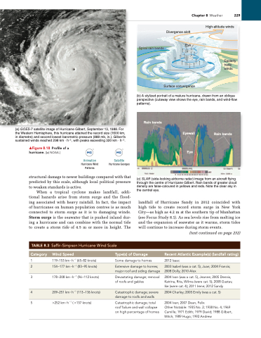
 (a) GOES-7 satellite image of Hurricane Gilbert, September 13, 1988. For the Western Hemisphere, this hurricane attained the record size (1600 km, in diametre) and second lowest barometric pressure (888 mb, in.). Gilbert’s sustained winds reached 298 km · h–1, with peaks exceeding 320 km · h–1.
(b) A stylized portrait of a mature hurricane, drawn from an oblique perspective (cutaway view shows the eye, rain bands, and wind-flow patterns).
(c) SLAR (side-looking airborne radar) image from an aircraft flying through the centre of Hurricane Gilbert. Rain bands of greater cloud density are false-coloured in yellows and reds. Note the clear sky in the central eye.
landfall of Hurricane Sandy in 2012 coincided with high tide to create record storm surge in New York City—as high as 4.2 m at the southern tip of Manhattan (see Focus Study 8.1). As sea levels rise from melting ice and the expansion of seawater as it warms, storm tides will continue to increase during storm events.
(text continued on page 232)
▲Figure 8.18 Profile of a hurricane. [(a) NOAA.]
structural damage to newer buildings compared with that predicted by this scale, although local political pressure to weaken standards is active.
When a tropical cyclone makes landfall, addi- tional hazards arise from storm surge and the flood- ing associated with heavy rainfall. In fact, the impact of hurricanes on human population centres is as much connected to storm surge as it is to damaging winds. Storm surge is the seawater that is pushed inland dur- ing a hurricane and can combine with the normal tide to create a storm tide of 4.5 m or more in height. The
TABLE 8.3 Saffir–Simpson Hurricane Wind Scale
Animation Satellite
Hurricane Wind Hurricane Georges Patterns
  Category
Wind Speed
Type(s) of Damage
recent Atlantic Example(s) (landfall rating)
1 119–153 km ∙ h−1 (65–82 knots) 3 178 –208 km ∙ h−1 (96 –112 knots)
5 >252 km ∙ h−1 ( >137 knots)
Some damage to homes
Devastating damage; removal of roofs and gables
Catastrophic damage; total roof failure and wall collapse on high percentage of homes
2012 isaac
 2
  154 –177 km ∙ h−1 (83 –95 knots)
  extensive damage to homes; major roof and siding damage
  2003 isabel (was a cat. 5), Juan; 2004 Francis; 2008 Dolly; 2010 Alex
  2004 ivan (was a cat. 5), Jeanne; 2005 Dennis, Katrina, rita, Wilma (were cat. 5); 2008 gustav, ike (were cat. 4); 2011 irene; 2012 Sandy
2004 ivan; 2007 Dean, Felix
Other Notable: 1935 No. 2; 1938 No. 4; 1969 Camille; 1971 edith; 1979 David; 1988 gilbert, Mitch; 1989 Hugo; 1992 Andrew
 4
  209–251 km ∙ h−1 (113 –136 knots)
  Catastrophic damage; severe damage to roofs and walls
  2004 Charley; 2005 emily (was a cat. 5)


