Page 264 - Geosystems An Introduction to Physical Geography 4th Canadian Edition
P. 264
 228 part II The Water, Weather, and Climate Systems
    Caribbean Sea
South America
Easterly wave
Upper-air wind
 s
  TABLE 8.2 Tropical Cyclone Classification
 Designation(s)
Winds
Features
Tropical disturbance
Tropical storm
Variable, low
63–118 km·h−1; 35–63 knots
Definite area of surface low pressure; patches of clouds
Closed isobars; definite circular organization; heavy rain; assigned a name
 Tropical depression
  Up to 63 km·h−1; up to 34 knots
  gale force, organizing circulation; light to moderate rain
    Hurricane (Atlantic and east Pacific) Typhoon
(West Pacific) Cyclone (indian Ocean, Australia)
  greater than 119 km · h−1; 64 knots
  Circular, closed isobars; heavy rain, storm surges; tornadoes in right-front quadrant
  pressure are not always the strongest or cause the most damage. The lowest central pressure for a storm in the Atlantic is 882 mb, recorded for Hurricane Wilma in 2005.
As winds rush toward the centre of a tropical cy- clone, they turn upward, forming a wall of dense rain bands called the eyewall—this is the zone of most in- tense precipitation. The central area is designated the eye of the storm, where wind and precipitation subside; this is the warmest area of the storm, and although clear skies can appear here they may not always be present, as com- monly believed. The structure of the rain bands, eyewall, and central eye are clearly visible for Hurricane Gilbert in Figure 8.18, from a top view, an oblique view (from an artist’s perspective), and a side-radar view.
Tropical cyclones range in diametre from a com- pact 160 km–1000 km to the 1300–1600 km attained by some western Pacific super typhoons. Vertically, a tropical cyclone dominates the full height of the troposphere. These storms move along over water at about 16–40 km · h−1. The strongest winds are usu- ally recorded in the right-front quadrant (relative to the storm’s directional path) of the storm. At landfall, where the eye moves ashore, dozens of fully developed tornadoes may be located in this high-wind sector. For example, Hurricane Camille in 1969 had up to 100 tor- nadoes embedded in its right-front quadrant.
Wave trough
Moist air Ocean
Dry air
(top view) Thunderstorms
Precipitation
(side view)
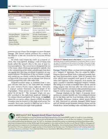
▲Figure 8.17 Easterly wave in the tropics. A low-pressure centre develops along an easterly (westward-moving) wave. Moist air rises in an area of convergence at the surface to the east of the wave trough. Wind flows bend and converge before the trough and diverge down- wind from the trough.
Damage Potential When you hear meteorologists speak of a “category 4” hurricane, they are using the Saffir– Simpson Hurricane Wind Scale to estimate possible dam- age from hurricane-force winds. Table 8.3 presents this scale, which uses sustained wind speed to rank hurri- canes and typhoons in five categories, from smaller cat- egory 1 storms to extremely dangerous category 5 storms. The rating is for winds at landfall; these speeds and the rating category may decrease after the storm moves in- land. This scale does not address other potential hurricane impacts, such as storm surge, flooding, and tornadoes.
Damage depends on the degree of property devel- opment at a storm’s landfall site, how prepared citizens are for the blow, and the local building codes in effect. For example, Hurricane Andrew, which struck Florida in 1992, destroyed or seriously damaged 70000 homes and left 200000 people homeless between Miami and the Florida Keys. Newer building codes will likely reduce the
 Georeport 8.5 Research Aircraft Dissect Hurricane Karl
in 2010, scientists launched the genesis and rapid intensification Processes (griP) mission to study hurricane develop- ment using satellites, aircraft, and unmanned aerial vehicles. in September, an aircraft flew into category 3 Hurricane Karl as it made landfall along the Mexican coast. At 11277 m, the plane collected data using nine instruments and launched dropsondes,
which record measurements as they fall through the atmosphere to the ocean surface. Another aircraft flew at 17000 m, using special- ized radiometers to measure rain-cloud systems and surface winds. Meanwhile, the remotely piloted Global Hawk flew over the storm for more than 15 hours, sampling the upper reaches of a hurricane for the first time ever. The Global Hawk aircraft is being used in the new 5-year Hurricane and Severe Storm Sentinel (HS3) mission launched in 2012. More information is at www.nasa.gov/mission_pages/ hurricanes/missions/grip/main/index.html.
    Divergence
Convergence


