Page 266 - Geosystems An Introduction to Physical Geography 4th Canadian Edition
P. 266
 230 part II The Water, Weather, and Climate Systems
 F cus Study 8.1 Natural Hazards
Hurricanes Katrina and Sandy: Storm Development and Links to Climate Change
     Hurricane Katrina, devastating the Gulf Coast in 2005, and Hurricane Sandy, slam- ming the mid-Atlantic coast in 2012, rank as the two most expensive hurricanes in U.S. history. Although both are memo- rable for destructiveness and human loss, the storms themselves differed greatly. And in the 7-year interval between them, public awareness of the impacts of cli- mate change on global weather events has increased.
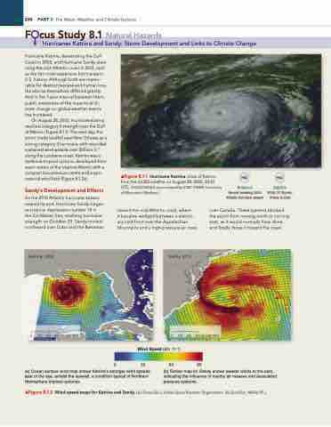
On August 28, 2005, Hurricane Katrina reached category 5 strength over the Gulf of Mexico (Figure 8.1.1). The next day, the storm made landfall near New Orleans as a strong category 3 hurricane, with recorded sustained wind speeds over 200 km·h−1 along the Louisiana coast. Katrina was a textbook tropical cyclone, developed from warm waters of the tropical Atlantic with a compact low-pressure centre and a sym- metrical wind field (Figure 8.1.2a).
Sandy’s Development and Effects
As the 2012 Atlantic hurricane season neared its end, Hurricane Sandy began as tropical depression number 18 in the Caribbean Sea, reaching hurricane strength on October 23. Sandy moved northward over Cuba and the Bahamas
▲Figure 8.1.1 Hurricane Katrina. View of Katrina from the GOES satellite on August 28, 2005, 20:45 UTC. [NASA/NOAA as processed by SSeC CiMSS, University of Wisconsin–Madison.]
Notebook
Record-breaking 2005 Atlantic hurricane season
Satellite
2005: 27 Storms, Arlene to Zeta
 toward the mid-Atlantic coast, where
it became wedged between a station- ary cold front over the Appalachian Mountains and a high-pressure air mass
over Canada. These systems blocked the storm from moving north or curving east, as it would normally have done, and finally drove it toward the coast.
    Katrina, 2005
 0 100 200 300 KILOMETRES
Wind Speed (km · h–1)
0 32 64 96
 (a) Ocean surface wind map shows Katrina’s stronger wind speeds east of the eye, amidst the eyewall, a condition typical of Northern Hemisphere tropical cyclones.
(b) Similar map for Sandy shows weaker winds to the east, indicating the influence of nearby air masses and associated pressure systems.
▲Figure 8.1.2 Wind-speed maps for Katrina and Sandy. [(a) OceanSat-2, indian Space research Organization. (b) QuickSat, NASA/JPL.]
Sandy, 2012
 0 100 200 300 KILOMETRES


