Page 437 - Geosystems An Introduction to Physical Geography 4th Canadian Edition
P. 437
 80°
ARCTIC OCEAN
70°
160°
Arctic Circle
60° 50° 40° 30°
ATLANTI C OCEAN
60° 50° 40° 30°
50° 40° 30°
PACIFIC OCEAN
Tropic of Cancer
50°
40°
30° 20° 10°
R
U
A
S
I
E
A
N
-
H
I
C
M
A
LY
A
O
A
R
N
S
D
Y
S
I
L
L
E
0° 140° 130°
10° 20° 30° 40° 50°
120° 110° 100° Equator
90°
0°
10° 20° 20° 30° 30° 40° 40° 50° 50°
60°
Tropic of Cancer 20° 20°
PACIFIC
10° 10°
OCEAN
S
50°
40°
40°
110° 120° 130° 140° 150° 160° 180°
0 1000 2000 3000 KILOMETRES
MODIFIED GOODE’S HOMOLOSINE EQUAL-AREA PROJECTION
Sedimentary Covers
Areas of sedimentary layers that
have not been subject to orogenesis. These areas of sedimentary rock form continuous covers over underlying structures.
Caledonian and Hercynian
(or Appalachian Remnants) Remains of mountain chains and ranges formed during the Paleozoic and Mesozoic Eras prior to the Cretaceous Period and experiencing no orogenesis since then.*
Isolated Volcanic Areas
Areas of volcanoes, active or extinct, with associated volcanic features, lying outside the Alpine mountain system and the rifted shield areas.
*Please refer to Figure 12.1, the geologic time scale.
20° 30°
20° 30°
40° 50°
20° Tropic of Capricorn 30°
CONTINENTAL 40°
10° 10°
OCEAN
120° 20°
30°
waves, is an earthquake, or quake. The two sides of the fault plane then lurch into new positions, moving dis- tances ranging from centimetres to several metres, and release enormous amounts of seismic energy into the
surrounding crust. This energy radiates throughout the planet, diminishing with distance.
The plate collision in which India is moving north- eastward at about 5 cm a year creates disruption that has
SHELF
50°
Alpine System
The world-girdling system of mountain chains and ranges formed since the Jurassic Period.*
Laurasian Shields
North of the great east–west portion of the Alpine system; areas of stable, massive blocks of Earth’s crust where rocks formed an encircling enclosure with no gap of more than 320 km (200 mi) between outcrops.
Rifted Shield Areas
Block-faulted areas of shields forming grabens together with associated horsts and volcanic features.
Gondwana Shields
South of the great east–west portion of the Alpine system.
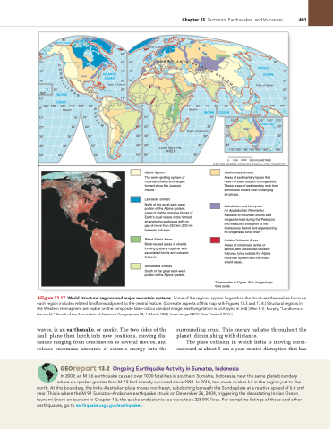
▲Figure 13.17 World structural regions and major mountain systems. Some of the regions appear larger than the structures themselves because each region includes related landforms adjacent to the central feature. (Correlate aspects of this map with Figures 13.3 and 13.4.) Structural regions in the Western Hemisphere are visible on the composite false-colour Landsat image inset (vegetation is portrayed in red) [After R. E. Murphy, “Landforms of the world,” Annals of the Association of American geographers 58, 1 (March 1968). Inset image EROS Data Center/USgS.]
Georeport 13.2 Ongoing Earthquake Activity in Sumatra, indonesia
In 2009, an M 7.6 earthquake caused over 1000 fatalities in southern Sumatra, Indonesia, near the same plate boundary where six quakes greater than M 7.9 had already occurred since 1998. In 2010, two more quakes hit in the region just to the
north. At this boundary, the Indo-Australian plate moves northeast, subducting beneath the Sunda plate at a relative speed of 6.6 cm/ year. This is where the M 9.1 Sumatra–Andaman earthquake struck on December 26, 2004, triggering the devastating Indian Ocean tsunami (more on tsunami in Chapter 16); the quake and seismic sea wave took 228000 lives. For complete listings of these and other earthquakes, go to earthquake.usgs.gov/earthquakes.
Chapter 13 Tectonics, Earthquakes, and Volcanism 401
T
E
M
R
A
N
50° Equator
70°
INDIAN
10°
80°
90°
140° 150°
150° 160° 170° CORAL SEA 20°
30°
Y
S
T
E
M


