Page 442 - Geosystems An Introduction to Physical Geography 4th Canadian Edition
P. 442
   406 part III The Earth–Atmosphere Interface
  F cus Study 13.2 Natural Hazards
Earthquakes in Haiti, Chile, and Japan: A Comparative Analysis
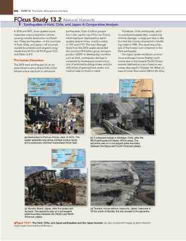
       In 2010 and 2011, three quakes struck areas near major population centres, causing massive destruction and fatali- ties. These earthquakes—in the countries of Haiti, Chile, and Japan—all occurred at plate boundaries and ranged in mag- nitude from M 7.0 to M 9.0 (Figure 13.2.1 and Table 13.2.1).
The Human Dimension
The 2010 Haiti earthquake hit an im- poverished country where little of the infrastructure was built to withstand
(a) Destruction in Port-au-Prince, Haiti, in 2010. The quake epicentre was along multiple surface faults and a previously unknown subsurface thrust fault.
earthquakes. Over 2 million people
live in the capital city of Port-au-Prince, which has been destroyed by earth- quakes several times, mostly notably
in 1751 and 1770. The total damage there from the 2010 quake exceeded the country’s $14 billion gross domestic product (gDP). In developing countries such as Haiti, earthquake damage is worsened by inadequate construction, lack of enforced building codes, and the difficulties of getting food, water, and medical help to those in need.
The Maule, Chile, earthquake, which occurred just 6 weeks later, caused only minimal damage, in large part due to the fact that the country enacted strict build- ing codes in 1985. The result was a frac- tion of the human cost compared to the Haiti earthquake.
The Japan quake resulted in an enor- mous and tragic human fatality count, mainly due to the massive Pacific Ocean tsunami (defined as a set of seismic sea waves; discussed in Chapter 16). When an area of ocean floor some 338 km (N–S) by
(b) A collapsed bridge in Santiago, Chile, after the M8.8 earthquake hit Maule, 95 km away. The epicentre was on a convergent plate boundary between the Nazca and South American plates.
(d) Tsunami moves ashore, Iwanuma, Japan. Iwanuma is 20 km south of Sendai, the city closest to the epicentre.
    80° 75° 70° 65°
  CUBA
ATLANTIC OCEAN
HAITI DOMINICAN REPUBLIC 20°
76° 74° 72°
34°
Santiago
PACIFIC OCEAN Maule
36° Concepción
CHILE
ARGENTINA
 Port-au-Prince
JAMAICA
Caribbean Sea
PUERTO RICO
15°
       38°
         NORTH KOREA
Sea of
Japan
JAPAN
 SOUTH
KOREA Nagoya
135°
145°
Sendai
PACIFIC
OCEAN
Tokyo
  Honshu
      (c) Honshu Island, Japan, after the quake and tsunami. The epicentre was on a convergent plate boundary between the Pacific and North American plates.
▲Figure 13.2.1 the Haiti, Chile, and Japan earthquakes and the Japan tsunami. [(a) Julie Jacobson/AP Images. (b) Martin Bernetti/ getty Images. (c) and (d) Kyodo/Reuters.]
40°
35°


