Page 440 - Geosystems An Introduction to Physical Geography 4th Canadian Edition
P. 440
 404 part III The Earth–Atmosphere Interface
 F cus Study 13.1 Natural Hazards Tectonic Setting of the Pacific Coast of Canada
    The Pacific Coast is the most seismically active region of Canada. This region is one of the few areas in the world where divergent, convergent, and transform plate boundaries occur in proximity to one another (Figure 13.1.1), resulting in significant earthquake activity. More than 100 earthquakes of magnitude 5 or greater (capable of causing dam- age) were recorded offshore in the past 75 years.
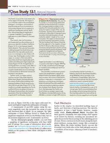
The oceanic Juan de Fuca plate, which extends from the northern tip of Vancouver Island to northern California (Figure 13.1.1), is moving east toward North America. The Juan de Fuca plate
is sliding beneath the North American plate within the Cascadia subduction zone at a convergence rate of about 40 mm per year. Earthquake activity in this region is unusual in that instruments record few small (low magnitude) earth- quakes and infrequent large magnitude events (Figure 13.1.2). A magnitude 7.3 earthquake that occurred in June 1946 on central Vancouver Island (Figure 13.1.3a) caused considerable structural damage in communities on Vancouver Island and resulted in two deaths.
Farther north, in a region extend-
ing from northern Vancouver Island to Haida Gwaii (Queen Charlotte Islands), the oceanic Pacific plate is sliding north- westward relative to North America at a rate of 60 mm per year (Figure 13.1.1). The transform boundary separating the Pacific and North American plates is known as the Queen Charlotte fault, the Canadian equivalent of the San Andreas fault. A magnitude 8.1 earthquake, Canada’s
▶Figure 13.1.1 Plate tectonic setting
of western North America. The Juan de Fuca plate is currently being subducted beneath the North American continent; the convergent plate boundary is indi- cated by the Cascadia subduction zone along the eastern margin of the Juan de Fuca plate. The blue arrow indicates the movement of this plate. A divergent plate boundary (indicated by green arrows) marks the western margin of the Juan de Fuca plate. This region is characterised
by active volcanism and seismic activity. The San Andreas Fault–Queen Charlotte fault lies adjacent to the coastline of west- ern North America. Blue arrows indicate movement along this fault. Seismic activity along this fault produces infrequent, large- magnitude (megathrust) earthquakes. [Reproduced with the permission of Natural Re- sources Canada, 2011. Courtesy of the Geological Survey of Canada.]
largest earthquake in recorded history, occurred on this fault in August 1949 (Fig- ure 13.1.3b). Limited structural damage
in mainland communities such as Prince Rupert resulted.
The Canadian and American govern- ments have established a network of Global Positioning System (GPS) receiv- ers to monitor the motion of the Earth’s surface in response to compression and shearing occurring along convergent plate boundaries (Cascadia subduction zone) and transform plate boundaries (San Andreas fault–Queen Charlotte fault, that separates the Pacific and North American plates), respectively. The Western Canada Deformation Array (WCDA), a network of eight GPS stations
0
250 500 KILOMETRES
  130 125
Queen Charlotte Fault
PACIFIC OCEAN
British Columbia
NORTH AMERICAN PLATE
Vancouver Is.
Vancouver Victoria
Seattle
Washington
Mt. St. Helens
Juan de Fuca Plate
40 mm/yr
PACIFIC PLATE
San Andreas Fault
Portland
Cascade Volcanoes
Oregon California
 in southwestern British Columbia, is linked to the Pacific Northwest Geodetic Array (PANGA), which operates in the northwestern United States. Data from these networks indicate that the Cascadia subduction zone is currently locked (www.seismescanada.rncan.gc.ca/zones/ westcan-eng.php) and that Vancouver Island is being compressed at a rate of 10 mm per year. Earth scientists believe that the energy currently being stored along the Cascadia subduction zone will be re- leased in a future megathrust earthquake.
As seen in Figure 13.19 this is the region with most fre- quent and highest magnitude earthquakes in Canada.
A reassessment of pre-1993 quakes using the mo- ment magnitude scale has increased the rating of some and decreased that of others. As an example, the 1964 earthquake at Prince William Sound in Alaska had an amplitude magnitude of 8.6 (on the Richter scale), but on the moment magnitude scale, it increased to an M 9.2.
On the MasteringGeography website, you will find a sampling of significant earthquakes with their MMI and M ratings. For a range of information about earth- quakes, see earthquake.usgs.gov/regional/neic/ or www.ngdc .noaa.gov/hazard/earthqk.shtml. Focus Study 13.2 offers more details on the quakes in Haiti, Chile, and Japan in 2010 and 2011.
Fault Mechanics
Earlier in the chapter, we described faulting, types of faults, and direction of faulting motions. The specific mechanics of how a fault breaks, however, remain under study. Elastic-rebound theory describes the basic process. Generally, two sides along a fault appear to be locked by friction, resisting any movement de- spite the powerful forces acting on the adjoining pieces of crust. Stress continues to build strain along the fault- plane surfaces, storing elastic energy like a wound-up spring. When the strain buildup finally exceeds the frictional lock, both sides of the fault abruptly move to a condition of less strain, releasing a burst of mechani- cal energy.
50
45
C
a
s
c
Juan de Fuca Ridge
a
d
i
a
S
u
b
d
u
c
t
i
o
n
Z
o
ne
40


