Page 445 - Geosystems An Introduction to Physical Geography 4th Canadian Edition
P. 445
 (a)
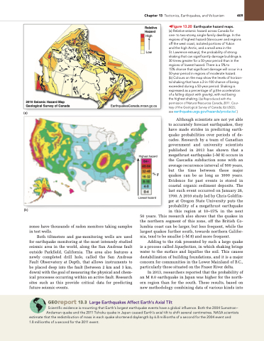
2010 Seismic Hazard Map Geological Survey of Canada
EarthquakesCanada.nrcan.gc.ca
shaking that can significantly damage buildings is 30 times greater for a 50-year period than in the regions of lowest hazard. There is a 5% to
15% chance that significant damage will occur in a 50-year period in regions of moderate hazard.
(b) Colours on the map show the levels of horizon- tal shaking that have a 2-in-100 chance of being exceeded during a 50-year period. Shaking is expressed as a percentage of g (the acceleration of a falling object with gravity), with red being
the highest shaking. [(a) Reproduced with the permission of Natural Resources Canada, 2011. Cour- tesy of the geological Survey of Canada; (b) USgS; see earthquake.usgs.gov/hazards/products/.]
Although scientists are not yet able to accurately forecast earthquakes, they have made strides in predicting earth- quake probabilities over periods of de- cades. Research by a team of Canadian government and university scientists published in 2013 has shown that a megathrust earthquake (~M 9) occurs in the Cascadia subduction zone with an average recurrence interval of 500 years, but the time between these major quakes can be as long as 1000 years. Evidence for past events is stored in coastal organic sediment deposits. The last such event occurred on January 26, 1700. A 2010 study led by Chris Goldfin- ger at Oregon State University puts the probability of a megathrust earthquake in this region at 10–15% in the next
(b)
zones have thousands of radon monitors taking samples in test wells.
Both tiltmeters and gas-monitoring wells are used for earthquake monitoring at the most intensely studied seismic area in the world, along the San Andreas fault outside Parkfield, California. The area also features a newly completed drill hole, called the San Andreas Fault Observatory at Depth, that allows instruments to be placed deep into the fault (between 2 km and 3 km, down) with the goal of measuring the physical and chem- ical processes occurring within an active fault. Research sites such as this provide critical data for predicting future seismic events.
50 years. This research also shows that the quakes in the northern segment of this zone, off the British Co- lumbia coast can be larger, but less frequent, while the largest quakes further south, towards northern Califor- nia, tend to be smaller (~M 8) and more frequent.
Adding to the risk presented by such a large quake is a process called liquefaction, in which shaking brings water to the surface and liquifies the soil. This causes destabilization of building foundations, and it is a major concern for communities in the Lower Mainland of B.C., particularly those situated on the Fraser River delta.
In 2013, researchers reported that the probability of an M 8.0 earthquake in Japan was higher for the north- ern region than for the south. These results, based on new methodology combining data of various kinds into
Georeport 13.3 Large Earthquakes Affect Earth’s Axial Tilt
Scientific evidence is mounting that Earth’s largest earthquake events have a global influence. Both the 2004 Sumatran– Andaman quake and the 2011 Tohoku quake in Japan caused Earth’s axial tilt to shift several centimetres. NASA scientists
estimate that the redistribution of mass in each quake shortened daylength by 6.8 millionths of a second for the 2004 event and 1.8 millionths of a second for the 2011 event.
Chapter 13 Tectonics, Earthquakes, and Volcanism 409
◀Figure 13.20 Earthquake hazard maps.
(a) Relative seismic hazard across Canada for High one- to two-storey, single-family dwellings. In the regions of highest hazard (Vancouver and regions
off the west coast, isolated portions of yukon
and the high Arctic, and a small area in the Low St. Lawrence estuary), the probability of strong
Relative Hazard
Highest hazard
%g
Lowest hazard


