Page 446 - Geosystems An Introduction to Physical Geography 4th Canadian Edition
P. 446
 410 part III The Earth–Atmosphere Interface
  a mathematical probability model, directly contradict Japan’s national seismic hazard map, which puts higher quake risk in the south. Once refined, the ability to pre- dict earthquakes over long time scales will be useful for hazard planning.
In the meantime, earthquake warning systems have been successfully implemented in some countries. A Mexico City warning system provides 70-second notice of arriving seismic waves. The system was effective in March 2012, when a senate hearing at the capitol was interrupted by the sirens indicating an imminent earth- quake. Shaking began about a minute later. In Japan, a warning system was activated during the Tohoku earth- quake, sending alerts to televisions and cell phones and automatically shutting down some transportation and industrial services. (The tsunami warning system in the Pacific is discussed in Chapter 16.)
Earthquake Planning
Someday accurate earthquake forecasting may be a reality, but several questions remain: How will humans respond to a forecast? Can a major metropolitan region be evacu- ated for short periods of time? Can a city relocate after a disaster to an area of lower risk?
Actual implementation of an action plan to reduce death, injury, and property damage from earthquakes is difficult to achieve. For example, such a plan is likely to be unpopular politically, since it involves large expen- ditures of money before a quake has even hit. Moreover, the negative image created by the idea of the possibility of earthquakes in a given municipality is not likely to be welcomed by banks, real estate agents, politi- cians, or the chamber of commerce. These factors work against the adoption of effective prediction methods and planning.
A valid and applicable generalization is that hu- mans and their institutions seem unable or unwilling to perceive hazards in a familiar environment. In other words, people tend to feel secure in their homes, even in communities known to be sitting on a quiet fault zone. Such an axiom of human behaviour certainly helps ex- plain why large populations continue to live and work in earthquake-prone settings. Similar statements also can be made about populations in areas vulnerable to floods, hurricanes, and other natural hazards. (See the Natural Hazards Center at the University of Colorado at www.colorado.edu/hazards/index.html.)
Volcanism
Volcanic eruptions across the globe remind us of Earth’s tremendous internal energy and of the dynamic forces shaping the planet’s surface. The distribution of ongo- ing volcanic activity matches the distribution of plate boundaries, as shown on the map in Figure 12.20, as well as indicating the location of hot spots. Over 1300 identifiable volcanic cones and mountains exist on Earth, although fewer than 600 are active.
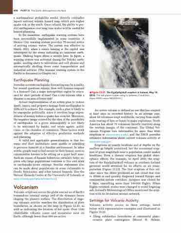
▲Figure 13.21 the Eyjafjallajökull eruption in iceland, May 10, 2010. The ash plume is seen rising to between 5 and 6 km.
[Aqua, MODIS sensor NASA/gSFC.]
An active volcano is defined as one that has erupted at least once in recorded history. In an average year, about 50 volcanoes erupt worldwide, varying from small- scale venting of lava or fumes to major explosions. North America has about 70 volcanoes (mostly inactive) along the western margin of the continent. The Global Vol- canism Program lists information for more than 8500 eruptions at www.volcano.si.edu/, and the USGS provides extensive information about current volcanic activity at volcanoes.usgs.gov/.
Eruptions in remote locations and at depths on the seafloor go largely unnoticed, but the occasional erup- tion of great magnitude near a population centre makes headlines. Even a distant eruption has global atmo- spheric effects. For example, in April 2010, the erup- tion of the Eyjafjallajökull volcano in southern Iceland garnered world attention for its effects on air trans- portation (Figure 13.21). The first eruption of this vol- cano since the 1820s produced an ash cloud that rose to 10660 m and quickly dispersed toward Europe and commercial airline corridors. Airspace was closed for 5 days, cancelling more than 100000 flights. When flights resumed, routes were changed to avoid lingering ash. Iceland’s Meteorological Office monitored the erup- tion with its 56-station seismic network.
Settings for Volcanic Activity
Volcanic activity occurs in three settings, listed below with representative examples and illustrated in Figure 13.22:
• Along subduction boundaries at continental plate– oceanic plate convergence (Mount St. Helens;
 Eyjafjallajökull


