Page 448 - Geosystems An Introduction to Physical Geography 4th Canadian Edition
P. 448
 412 part III The Earth–Atmosphere Interface
 crust that develops folds as the lava cools. Both forms can come from the same eruption, and sometimes pahoehoe will become aa as the flow progresses. Other types of ba- saltic magma are described later in this section.
During a single eruption, a volcano may behave in sev- eral different ways, which depend primarily on the chemis- try and gas content of the lava. These factors determine the lava’s viscosity, or resistance to flow. Viscosity can range from low (very fluid) to high (thick and flowing slowly). For example, pahoehoe has lower viscosity than aa.
Volcanic Landforms
Volcanic eruptions result in structures that range among several forms, such as hill, cone, or mountain. In a vol- canic mountain, a crater, or circular surface depression, is usually found at or near the summit (see Figures 13.29 and 13.30b).
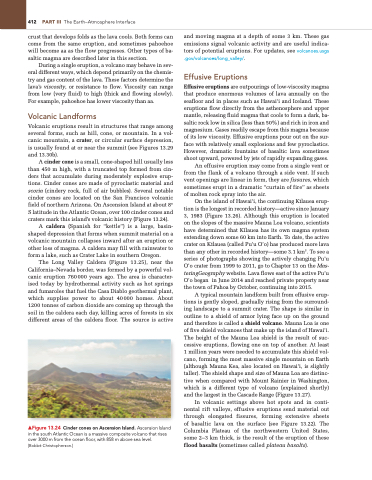
A cinder cone is a small, cone-shaped hill usually less than 450 m high, with a truncated top formed from cin- ders that accumulate during moderately explosive erup- tions. Cinder cones are made of pyroclastic material and scoria (cindery rock, full of air bubbles). Several notable cinder cones are located on the San Francisco volcanic field of northern Arizona. On Ascension Island at about 8° S latitude in the Atlantic Ocean, over 100 cinder cones and craters mark this island’s volcanic history (Figure 13.24).
A caldera (Spanish for “kettle”) is a large, basin- shaped depression that forms when summit material on a volcanic mountain collapses inward after an eruption or other loss of magma. A caldera may fill with rainwater to form a lake, such as Crater Lake in southern Oregon.
The Long Valley Caldera (Figure 13.25), near the California–Nevada border, was formed by a powerful vol- canic eruption 760000 years ago. The area is character- ised today by hydrothermal activity such as hot springs and fumaroles that fuel the Casa Diablo geothermal plant, which supplies power to about 40000 homes. About 1200 tonnes of carbon dioxide are coming up through the soil in the caldera each day, killing acres of forests in six different areas of the caldera floor. The source is active
▲Figure 13.24 Cinder cones on Ascension Island. Ascension Island in the south Atlantic Ocean is a massive composite volcano that rises over 3000 m from the ocean floor, with 858 m above sea level.
[Bobbé Christopherson.]
and moving magma at a depth of some 3 km. These gas emissions signal volcanic activity and are useful indica- tors of potential eruptions. For updates, see volcanoes.usgs .gov/volcanoes/long_valley/.
Effusive Eruptions
Effusive eruptions are outpourings of low-viscosity magma that produce enormous volumes of lava annually on the seafloor and in places such as Hawai‘i and Iceland. These eruptions flow directly from the asthenosphere and upper mantle, releasing fluid magma that cools to form a dark, ba- saltic rock low in silica (less than 50%) and rich in iron and magnesium. Gases readily escape from this magma because of its low viscosity. Effusive eruptions pour out on the sur- face with relatively small explosions and few pyroclastics. However, dramatic fountains of basaltic lava sometimes shoot upward, powered by jets of rapidly expanding gases.
An effusive eruption may come from a single vent or from the flank of a volcano through a side vent. If such vent openings are linear in form, they are fissures, which sometimes erupt in a dramatic “curtain of fire” as sheets of molten rock spray into the air.
On the island of Hawai‘i, the continuing K-ılauea erup- tion is the longest in recorded history—active since January 3, 1983 (Figure 13.26). Although this eruption is located on the slopes of the massive Mauna Loa volcano, scientists have determined that K-ılauea has its own magma system extending down some 60 km into Earth. To date, the active crater on K-ılauea (called Pu’u O’o) has produced more lava than any other in recorded history—some 3.1 km3. To see a series of photographs showing the actively changing Pu’u O’o crater from 1999 to 2011, go to Chapter 13 on the Mas- teringGeography website. Lava flows east of the active Pu’u O’o began in June 2014 and reached private property near the town of Pahoa by October, continuing into 2015.
A typical mountain landform built from effusive erup- tions is gently sloped, gradually rising from the surround- ing landscape to a summit crater. The shape is similar in outline to a shield of armor lying face up on the ground and therefore is called a shield volcano. Mauna Loa is one of five shield volcanoes that make up the island of Hawai‘i. The height of the Mauna Loa shield is the result of suc- cessive eruptions, flowing one on top of another. At least 1 million years were needed to accumulate this shield vol- cano, forming the most massive single mountain on Earth (although Mauna Kea, also located on Hawai‘i, is slightly taller). The shield shape and size of Mauna Loa are distinc- tive when compared with Mount Rainier in Washington, which is a different type of volcano (explained shortly) and the largest in the Cascade Range (Figure 13.27).
In volcanic settings above hot spots and in conti- nental rift valleys, effusive eruptions send material out through elongated fissures, forming extensive sheets of basaltic lava on the surface (see Figure 13.22). The Columbia Plateau of the northwestern United States, some 2–3 km thick, is the result of the eruption of these f lood basalts (sometimes called plateau basalts).


