Page 450 - Geosystems An Introduction to Physical Geography 4th Canadian Edition
P. 450
 414 part III The Earth–Atmosphere Interface
     5800 m deep
Mauna Loa 4169 m 4392 m
Mount Rainier 190 km
K¯ılauea
Ocean
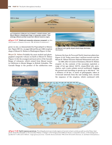
   (a) Comparison of Mauna Loa in Hawai’i, a shield volcano, and Mount Rainier in Washington State, a composite volcano. Their strikingly different profiles reveal their different tectonic origins.
▲Figure 13.27 Shield and composite volcanoes compared. [(a) After USgS, Eruption of Hawaiian Volcanoes, 1986. (b) Bobbé Christopherson.]
grows in size, as demonstrated by Popocatépetl in Mexico (see Figure HD 13c, on page 418) and the pre-1980-eruption shape of Mount St. Helens in Washington (Figure 13.30a).
Mount St. Helens Probably the most studied and photo- graphed composite volcano on Earth is Mount St. Helens (Figure 13.30), the youngest and most active of the Cascade Range of volcanoes, which extend from Mount Lassen in California to Mount Meager in British Columbia. The Cascade Range is the product of the subduction zone
(b) Mauna Loa’s gently sloped shield shape dominates the horizon.
between the Juan de Fuca and North American plates (see Figure 13.12). Today, more than 1 million tourists visit the Mount St. Helens Volcanic National Monument each year.
In 1980, after 123 years of dormancy, Mount St. Helens erupted. As the contents of the mountain exploded, a surge of hot gas (about 300°C), steam-filled ash, pyro- clastics, and a nuée ardente moved northward, hugging the ground and travelling at speeds up to 400 km·h−1 for a distance of 28 km. A series of photographs, taken at 10-second intervals from the east looking west, records the sequence of the eruption, which continued with
        100° 80° 60° 40° 20° 0° 20° 40° 60° 80° 100° 120° 140° 160° Arctic Circle
80°
         60°
Tropic of Cancer
HAWAII
PACIFIC
40°
60°
▲Figure 13.28 Earth’s igneous provinces. Flood basalt provinces include regions of ancient volcanic activity as well as active flows. Inset photo shows flood basalts on the Columbia Plateau in Oregon in the foreground and Mount Hood, a composite volcano, in the background. [(a) After M. F. Coffin and O. Eldholm, “Large igneous provinces,” Scientific American (October 1993): 42–43. © Scientific American, Inc. (b) Robert Christopherson.]
SIBERIAN TRAPS
 COLUMBIA RIVER FLOOD BASALTS
NORTH ATLANTIC VOLCANIC MARGIN
ATLANTIC OCEAN
Tropic of Capricorn
Antarctic Circle
60°
PACIFIC
Equator
  40°
40°
OCEAN
0°
    20°
0°
20°
DECCAN TRAPS
                OCEAN
KAROO BASALTS
CHAGOS- LACCADIVE RIDGE
MASCARENE PLATEAU
REUNION
INDIAN OCEAN
ONTONG JAVA PLATEAU
 20°
              KERGUELEN PLATEAU
BROKEN RIDGE PLATEAU
0 1500 3000 KILOMETRES
       60°
        9969 m


