Page 452 - Geosystems An Introduction to Physical Geography 4th Canadian Edition
P. 452
 416 part III The Earth–Atmosphere Interface
Subduction–zone Volcanoes
PACIFIC OCEAN
Motion at Convergent
Mount Churchill
= Volcano
North American
in British Columbia and Washington. Airborne ash can re- sult in severe damage to aircraft and represents the most important short-term hazard risk for the Canadian public. Debris flows (lahars) and floods (jökulhlaups) produced by the rapid melting of ice and snow on mountain summits can flow rapidly downslope and be extremely destructive.
One of the most recent volcanic events in Canada is a small flood basalt near New Aiyansh, B.C. This occurred about 250 years ago when there was an effusive eruption over a period of a few days. Lava flowed a cinder cone down the Tseax River valley and into the Nass River, de- stroying two Nisga’a villages. The hardened lava covers an area of about 40 km2, and it caused a number of geomor- phic changes in the landscape in response to the fluvial system being blocked.1
Volcano Forecasting and Planning
After 23000 people died in the 1985 eruption of Nevado del Ruiz in Colombia, the USGS and the Office of Foreign Disaster Assistance established the Volcano Disaster Assistance Program (VDAP; see vulcan.wr.usgs.gov/Vdap/). In the United States, VDAP helps local scientists forecast eruptions by setting up mobile volcano-monitoring systems at sites with activity or with vulnerable populations. A number of “volcano cams” are positioned around the world for 24-hour surveillance (go to vulcan .wr.usgs.gov/Photo/volcano_cams.html).
CRitiCaLthinking 13.2 Ocean-Floor Tectonics Tour
Using the chapter-opening map, follow the ocean ridge and spreading centre known as the East Pacific Rise northward as it trends beneath the west coast of the North American plate, disappearing under earthquake-prone California. Locate continents, offshore submerged continental shelves, and expanses of sediment-covered abyssal plain on the map.
On the floor of the Indian Ocean, you see the wide track along which the Indian plate travelled northward to its colli- sion with the Eurasian plate. Vast deposits of sediment cover the Indian Ocean floor, south of the ganges River and to the east of India. Sediments derived from the Himalayan Range blanket the floor of the Bay of Bengal (south of Bangladesh) to a depth of 20 km. These sediments result from centuries of soil erosion in the land of the monsoons.
In the Pacific, a chain of islands and seamounts marks the hot-spot track on the Pacific plate from Hawai‘i to the Aleu- tians. Visible as dark trenches are subduction zones south and east of Alaska and Japan and along the western coast of South and Central America. Follow the Mid-Atlantic Ridge spreading centre the full length of the Atlantic to where it passes through Iceland, sitting astride the ridge. Take time with this map and find other examples in it of the many con- cepts discussed in Chapters 12 and 13. •
1M. C. Roberts and S. J. McCuaig, “Geomorphic responses to the sudden blocking of a fluvial system: Aiyansh lava flow, north- west British Columbia,” The Canadian Geographer, 45 (2001): 319 –323.
Plate Boundary
Edgecombe Lava
Motion on Queen Charlotte Fault—a Transform
Fault
Pacific
Plate
Motion at Divergent Plate Boundary
Hoodoo
Iskut Fork
Tseax
Volcanoes crustal rifting
Convergent Plate Boundary
Motion at Baker Convergent Plate Boundary
Meager Fuca Plate
Nazko CANADA Wells Gray
Garibaldi
Juan de
Subduction–zone Volcanoes
Edziza
120 associated with60
Volcano Mountain
Yukon
Hot-spot Volcanoes
Plate
Northwest Territories
British
Columbia Alberta
Tuya Volcanic Field
Plate Motion
UNITED STATES
0 250 500 KILOMETRES
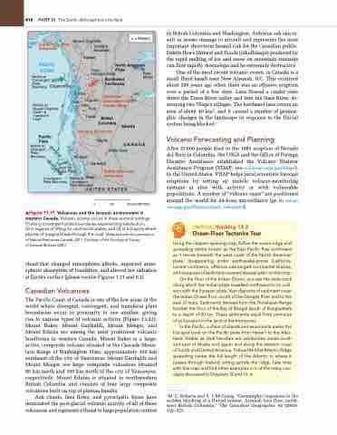
▲Figure 13.31 Volcanoes and the tectonic environment in western Canada. Volcanic activity occurs in three tectonic settings: (1) along convergent plate boundaries experiencing subduction;
(2) in regions of rifting on continental plates; and (3) at hot spots where plumes of magma break through the crust. [Adapted with the permission of Natural Resources Canada, 2011. Courtesy of the geological Survey
of Canada (Bulletin 548).]
cloud that changed atmospheric albedo, impacted atmo- spheric absorption of insolation, and altered net radiation at Earth’s surface (please review Figures 1.11 and 6.1).
Canadian Volcanoes
The Pacific Coast of Canada is one of the few areas in the world where divergent, convergent, and transform plate boundaries occur in proximity to one another, giving rise to various types of volcanic activity (Figure 13.32). Mount Baker, Mount Garibaldi, Mount Meager, and Mount Edziza are among the most prominent volcanic landforms in western Canada. Mount Baker is a large, active, composite volcano situated in the Cascade Moun- tain Range of Washington State, approximately 100 km southeast of the city of Vancouver. Mount Garibaldi and Mount Meager are large composite volcanoes situated 80 km north and 150 km north of the city of Vancouver, respectively. Mount Edziza is situated in northwestern British Columbia and consists of four large composite volcanoes built on top of plateau basalts.
Ash clouds, lava flows, and pyroclastic flows have dominated the post-glacial volcanic activity of all of these volcanoes and represent a threat to large population centres


