Page 453 - Geosystems An Introduction to Physical Geography 4th Canadian Edition
P. 453
Chapter 13 Tectonics, Earthquakes, and Volcanism 417
        2950 m
 Bulge
Magma chamber
Fault zone
        Ash and incandescent gas cloud
Landslide
                 Animation
Debris Avalanche and Eruption of Mount St. Helens
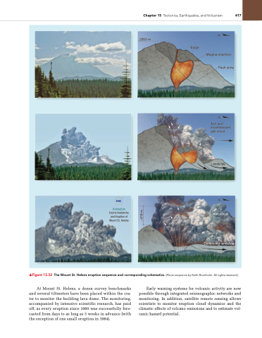
   ▲Figure 13.32 the Mount St. Helens eruption sequence and corresponding schematics. [Photo sequence by Keith Ronnholm. All rights reserved.]
At Mount St. Helens, a dozen survey benchmarks and several tiltmeters have been placed within the cra- ter to monitor the building lava dome. The monitoring, accompanied by intensive scientific research, has paid off, as every eruption since 1980 was successfully fore- casted from days to as long as 3 weeks in advance (with the exception of one small eruption in 1984).
Early warning systems for volcanic activity are now possible through integrated seismographic networks and monitoring. In addition, satellite remote sensing allows scientists to monitor eruption cloud dynamics and the climatic effects of volcano emissions and to estimate vol- canic hazard potential.
2532 m
Ash cloud
Continuing landslide
 –418 m


